7-11 October 2020. Palo Duro Canyon, Texas. During the summer of 2019, we participated in a Jeep Jamboree event in Wyoming. We had such a good time, that we signed up for a Jeep Jamboree in Texas for 2020. It was supposed to happen in May, but was rescheduled for October. So, with very little rest at home after our Utah adventures, we headed toward Amarillo and the Palo Duro Canyon for this year’s Jeep Jamboree Event.
Palo Duro is a 60 mile long canyon that opens up in the middle of the desert. It is the second largest canyon in the US. The websites claim it is the most spectacular and scenic spot in the Texas panhandle. The canyon descends down to 800 ft, but where we were it was closer to a 500 ft drop. The Jeep Jamboree people hooked up with a private landowner (cattle rancher) who owns a huge amount of the canyon and lets large groups explore his property (you have to watch out for cows!). (There is also a Palo Duro Canyon State Park – same canyon, but further west – which is not where we were, they don’t allow 4×4’ing).
The rancher allowed our group to dry camp on the ridge above the canyon, then in the morning, the Jeep Jamboree folk took about 140 jeeps (in eight groups) down the very steep and narrow trail to the canyon floor. We chose to be in a “mid level skill” group and were surprised by the constant obstacles that we encountered, but we had a great time for two days of hard wheelin’.
Here are some of the Jeeps lined up and waiting their turn to head down the canyon trail.To head into the canyon, we left the “Main Road” and took the “Horse Trail”. That was definite foreshadowing of the difficulty level for our adventure.Our GPS said this trail was a 500 ft drop to the canyon floor, but quite the view going down!At the bottom of the canyon, you get see the beauty of the area. – and how dry it is…Many of the trails were rocky.Many of the trails were steep.Many of the trails didn’t look much like trails.Sometimes you had to help each other get through!This obstacle was called Coyote Crawl. If your Jeep has good articulation, you drove through it like this.If your Jeep articulation isn’t great/ or you forget to undo the sway bar, then this happens. Oh dear!Why are all these jeeps waiting patiently coming off the hill?Because this guy’s tire came off his rim! Got it patched up and off everyone went.We had a slow climb getting out of the canyon!It was a bit foggy in the rancher’s field the morning we left.
We are already making plans to do another Jeep Jamboree Event in 2021!
Part 5 shows the last few days of our Canyons and Waves adventure near the Utah/Arizona border.
26-29 StateLine campground. This campground straddles the border of Utah and Arizona. It drove us crazy for a while, because we could never figure out what time it was – the phones and the truck just wouldn’t match! So we forced the phones to Denver time and just calculated the right time zones in our heads… Stateline campground is about a mile south of the entrance to Wire Pass and also the Wave hikes. Our plan was to get to this free campground early, snag one of the eight sites for four nights. We would hike the Wire Pass trail into Buckskin Gulch as a warm up, take a day off to rest our bodies, then hike the Wave on the 29th.
We found a very nice site at the Stateline Campground, covered picnic tables and bbq pits!
The Wire Pass day hike also requires a permit, but you can pay for it right at the trailhead, so that’s what we did. The Wire Pass trail is about 1.7 miles and dead ends onto the Buckskin Gulch trail. (Buckskin Gulch is part of the multi-day Paria Canyon Trail hike that we mentioned in Part 2).
We actually went north in Buckskin Gulch about a mile, turned around and went back to the intersection, then went south in Buckskin Gulch about 1.5 miles. (Then turned around and went back across Wire Pass). The next time we come here (and it was cool enough that we will come back), I think we will spend all our time going south. It was just a more interesting hike in that direction…
This is the beginning (and end) of the Wire Pass Trail. It is pretty open and gets VERY hot in the afternoon! (Bring water if you come).Wire Pass trail has some skinny parts (also a dry waterfall that we bypassed).At the intersection, we headed north on the Buckskin Gulch trail.I think maybe hikers must have filled these holes with pebbles?There were neat rocks going north.I think that spire at the top looks like a saber tooth tiger head!When the trail opened up, we turned around and headed south.Going south, Buckskin Gulch got narrower, and there were occasional puddles of mud – which were easy to step in – don’t ask me how I know!The rock formations were grand and beautiful!Here you can see where a flash flood left debris high overhead. Rain is dangerous here! (Chuck is carrying my hat so I can concentrate on getting mud off my boot!)Occasionally, you can see where the walls have collapsed over time, leaving rubble on the ground.We ran into this little critter, probably a Marten (type of weasel).This is as far south as we went, turned around and headed back. Probably 8.5 mile day.
The Wave. We had tried for five years to get a permit to hike The Wave. The BLM office only issues permits for 20 people a day to hike this area. Ten people via a internet lottery four months in advance, and ten people via a lottery of those that show up the night before. There are hundreds of people who are disappointed not to get a spot every day! I’m very glad we persevered, it was a GREAT experience. Chuck says sometimes I put in too many photos, but I think this time you’ll enjoy them!
The hike (definitely NOT a stroll) to The Wave is 2.7 miles of climbs and descents over rocks and sand.(You get a brightly colored permit that you must wear on your backpack to verify you are allowed to be there – ours was pink).The BLM office gives you a map, of sort, with pictures to help you identify landmarks along the way.If it hasn’t rained in a while, you can see footprints from previous hikers in the sandy areas to help lead you the right way. (Unless the wind has blown them away).This is the final climb to The Wave.The Wave (with Chuck to show scale)There are three main “waves” at The Wave.We left on the hike pretty close to sunrise, so we had some amazing colors.Looking down at the main wave.This is one of the side waves. It almost glowed in the morning light!Us standing here gives a better perspective of how large everything is!I just couldn’t get over how beautiful it was!Looking into a side waveI thought this looked a bit like bleachers.Here is a colorful canyon near The Wave.Everywhere you turned, there were more colorful formations!Can you imagine how the earth swirled and settled millions of years ago?So many layers of ground showing, so very colorful!Sometimes the swirls are mountainsSometimes they are valleysTime to hike back.You can see one of the few trailposts here.Karen and Chuck at The Wave!
The Wave hike was the highlight of our Canyons and Waves trip. I’m so very glad we got our permit and finally made it here!
Here is part 4 of our Canyons and Waves adventure near the Utah/Arizona border.
20-22 September. Lone Rock Campground. We headed to the BLM Lone Rock Campground on Lake Powell near Page, AZ. This is a huge spot on the beach that allows you to camp anywhere you like for a small fee. We have stayed here a few times before, so we headed down the sand near the water and parked. Unfortunately, this campground is suffering from the renewed enthusiasm of folk who want to get away from their houses because of COVID, but don’t really know about basic camping etiquette (like quiet times at night). This phenomena is especially prevalent on weekends, and we arrived on a Sunday. So, we experienced a more wild night than we are used to the first night, and found a better spot further away from the water (and crowd) for the next few nights. We picked this area to take advantage of Page for our restocking routine, groceries, laundry and basic camper cleaning and maintenance. We also got to launch our Kayak on Lake Powell and kayak in Antelope Canyon. This is only a couple of mile kayak trip up the canyon, and then you can continue further up the canyon by hiking. This hike did not show off the beauty that you can see on the commercial tours of Antelope Canyon, but those commercial tours were closed because of COVID.
Here is the “Lone Rock” at Lone Rock Campground – Lake Powell.Some days our views are not beautiful.Paddling on Lake Powell to get to Antelope Canyon.Antelope Canyon out on the water, not as dramatic as the commercial tours further inland, but still really cool!This is the colorful “parking spot” for all the Kayaks that paddle to the end of the water at Antelope Canyon and want to hike.Ack! We found a Baby Rattlesnake on our hike up Antelope Canyon! Back to the water for us!
23 September. Crosby Canyon. After getting restocked, we headed across a creek and along to the north shores of Lake Powell. This is a much more peaceful and rugged area, and we shared our first spot in Crosby Canyon with a view of less than half a dozen other campers, a family of Coyotes, a few birds and a few bats.
The roads on the north rim of Lake Powell are definitely ‘less traveled’.There are cool rock features as you head into Crosby Canyon.The GPS said that we were in the water! I guess water levels were down a bit.There were not too many people sharing this beach in Crosby Canyon!Camping at the beach in Crosby Canyon.Here is momma coyote finding a fish for her babies.All those nooks and crannies in the hills make great spots for bats to live, I guess.Sunset in Crosby Canyon.
24-25 September. Alstrom Point. Continuing east along the north side of Lake Powell is one of our favorite dispersed camping spots, Alstrom Point. It takes a high clearance 4×4 to get all the way out there. The views from this area are just incredible; you can watch the lights from the stars above and the lights from the parked houseboats hundreds of feet below on the lake. We were lucky this time with great weather, and the colors of the area just popped out!
We camped perched at the top of this cliff for our views!Alstrom Point overlooking Lake Powell.Our view at Alstrom Point.View from our back window (before the wind came up and broke the window).You can see the houseboats parked on the beach way below.Lake Powell from Alstrom Point at sunset.Lake Powell vistas from Alstrom Point.
Here is our continuation of our Canyons and Waves adventure near the Utah/Arizona Border.
14-15 September. Kodachrome State Park. We spent the next two nights at beautiful Kodachrome State Park in Utah. This wasn’t our first is visit to this park, so we skipped the easier trails we had done before and struck out on the Panorama Trail. Beautiful views all around, a couple of slots and spires, and even a little bonus of internet service at the very peak of Panorama Point!
This is the colorful view from the top of Panorama Point at Kodachrome State Park.Along the Panorama Trail was a short slot canyon called Secret Passage.Another view along the Panorama Trail.One of the many spires at Kodachrome State Park.
16 September. Lower Hackberry Slot Canyon. We took off south on Cottonwood Rd and stopped for our hike of the day at Hackberry Slot Canyon. This canyon was a bit different, fairly wide, with some bushes and trees growing on the bottom… From our research, we were expecting a 4-5 inch stream flowing through, but apparently not in September. There was plenty of sand, though, enough that we hiked half the trail barefoot! (Just to keep the sand from piling up in our water shoes). We spend the night at the BLM White House campground and were entertained by Uber-like drivers dropping off people to hike the 3-5 day (45 mile) Paria Slot Canyon trail. They were certainly tougher than us!
Cottonwood Road, along what they refer to as a Cockscomb mountain ridge.The Hackberry Slot Canyon Trail, can you see Chuck’s shoes hanging from his backpack?The Hackberry Canyon was wide, but still very deep!A few boulders in Hackberry Canyon.Hackberry Canyon was very colorful!We got to camp next to a huge sandstone boulder at White House campground.
17 September. Toadstools and Sand Dunes. We did a quick hike to see Toadstools and then headed to Corral Pink Sand Dunes State Park. This sand dune area was certainly bigger than the sand dunes area in Northern Colorado, and is known for several movies filmed there. We saw plenty of people playing with motor “toys” there.
The Toadstools hike was just a quick 1 mile hike off the main Hwy 89. Just amazing seeing these rocks wearing hats!Lots of sand at Corral Pink Sand Dunes State Park, but I thought the sand was more orange than pink…
18-19 September. Toroweap. This spot on the north rim of the Grand Canyon has been on our “bucket list” for quite a while! To get there, you go down a dirt road for 60 miles, drive through the Grand Canyon- Parashant National Monument and then arrive at a big Grand Canyon National Park sign and a tiny Grand Canyon Ranger Station manned by a young volunteer who stares at our rig and says, “you know, you need to be less than 22 ft long to make it through the rough and twistee road”. After assuring her that we were indeed only 21.5 ft long, and her verifying our two day camping permit, she let us tackle the rugged 4×4 road to Toroweap Point and the Tuweep campground.
There are two 60 mile dirt roads out to Toroweap. We took one out and the other back. Would recommend sticking to the east one if you are heading out there.The Toroweap Cliffs on the way in were beautiful!The road inside Grand Canyon NP were a bit rugged.Short hike to the edge of the Grand Canyon.Here is Chuck getting close to the edge – 3000 feet straight down..View of the Colorado River in the Grand Canyon from Toroweap PointFrom this point you can see the rapids on the Colorado River, and the rafters on “tequila beach” (where the rafters celebrate surviving the rapids). This is the only overlook in the National Park where you can see the river directly below.Grand Canyon view from Toroweap point, looking east.The Tuweep campground was about a mile from the point, and we found a boulder to camp next to! We were the only “big-rig” (non-tent) in the campground – as Chuck likes to say, the only one getting a hot shower in the morning!There were plenty of short, pretty hikes to occupy our time!We took a picture of this guy who got way closer to the edge than we would have! (See his Dad yelling at him to be careful from a safe distance on the left?)
We are continuing our adventure near the Utah/Arizona border.
9 September. Grand Staircase-Escalante National Monument. We started off the day with a hike up the Calf Creek Canyon. After three miles, you are rewarded with a beautiful waterfall! Then we loaded up the trucks and headed to Hell’s Backbone Road. We found some very interesting geology formations – wouldn’t want to drive my covered wagon across them – but other than washboard on the road, and the narrow bridge with great scary views, it wasn’t that bad… We were the only ones at the tiny (six site) Blue Spruce campground near the top of Hells Backbone – nice and quiet. It was cold enough to that the rangers came by to turn the water off to keep pipes from freezing, but they came by in the morning and turned it back on! Our friends Kurt and Anna departed for some different adventures, but we hope to camp with them again soon!
Found some parking at the Calf Creek trailhead (this isn’t always that easy, it is a very popular hike).Did I mention that Kurt and Anna brought their camping cat? She decided to go on an explore of her own… here is Kurt convincing her to return.Starting up the Calf Creek Trail, scenery is magnificent.This waterfall is spring-fed, so it usually has the same flow all year long.Lunch stop view from our window along Highway 12. You can just see interesting geology for miles and miles.Sharing a bit of shade along Hells Backbone Road. View looking out from the bridge at Hells Backbone. Quite Rugged.The new (1965), improved one lane Hells Backbone bridgeOur camping spot at Blue Spruce was lush and quiet!And the view out of our back window was a trickling stream!Kurt and Anna’s Camping Cat.
10-12 September. Hole in the Rock Road. Near the town of Escalante there is a dirt road that has a grand history. A group of Mormons built the road to get to the water (Glen Canyon/Colorado River/ now Lake Powell). But the only break in the rock cliff mountains was a tiny “hole” 50 miles down the mountain range with a steep descent to the river. Along the road are several interesting natural and historical sites. We hiked Zebra Slot Canyon, but found it a bit “icky” – the water was about mid-thigh high and was pretty stagnant and murky. And at our age, we really didn’t have the agility to “catwalk” the narrow passage. So we didn’t go deep into that canyon. After driving around on the wash-boardy roads, we found a camping spot along the way to Harris Wash. Beautiful spot, and it even had Internet! We spent two nights there, relaxing and reading, our friends who were tracking us with our in-reach GPS device worried that things had gone wrong because we were out in the middle of nowhere and we weren’t moving! We have great friends!
Meandered a bit at Devils Kitchen along Hole in the Rock Road.Loved this pic of an arch at Devils Kitchen.Hike to Zebra slot canyon.Entrance of Zebra slot canyon.Not too deep into Zebra slot canyon. Yes, the water was that color! And the slot was that narrow!We found this nice camping spot along Harris Wash Road. This canyon was right next to our camping spot. Great little hike!Our peaceful spot along Harris Wash Road.
13 September. Escalante. We spent a day doing laundry and gathering groceries in Escalante. Would you believe the grocery store there was not open on Sunday? Next stop, Kodachrome State Park.
6 September – 1 October. Canyons and Waves – Utah/Arizona Adventure.
First one of our friends suggested a May trip that got us thinking about how beautiful the Utah/Arizona border area was. Because of Covid, that trip got cancelled. Then, because of Covid, our long trip to Canada got cancelled. Then, low and behold, after five years of playing the “Wave” permit lottery, we finally got selected for a permit for that hike. So, we created a month long adventure to enjoy the Utah/Arizona area and end up with our hike on the “Wave”.
6 September – James M Robb State Park. We frequently pass this Colorado State Park on what used to be an island in the middle of the Colorado River as we travel down highway 70 near DeBeque Canyon. We thought we’d give it a try for our first night of this trip. It was very hot, but really nice. Seemed to have good river swimming, too.
James Robb campground in the DeBeque Canyon (along the Colorado River)
7-8 September. Capitol Reef National Park. Then we headed on down to Capitol Reef. Those of you who have known me for a while know that this is where I broke my arm (hiking) ten years ago. I was much more careful this time! Unluckily, the smoke from the California fires seemed to be catching up to us, but here are a few pics. We enjoy driving along the Capitol Reef Scenic Drive (canyon), even got out and did a little hike. We were lucky enough to meet up with some fellow XP Campers, Kurt and Anna, and spend some good times with them.
Fruita Campground at Capitol Reef. Room for two XP’s here!Driving down the scenic drive – the lack of blue skies just dulls all the colors!See those little stairs? That’s the beginning of the hike.Short hike on edge of canyon.View of the Scenic Drive from the hike – you can see how smokey it is!Two XPs!
The next day we all headed off to Notom Bullfrog Basin road and hiked The Headquarters slot canyon. The road is along a “fold” in the earth and there are several slot canyons in the area. Kurt and Anna are geo-cachers, so we were able to track down a treasure out in the middle of nowhere. Then we headed up the Burr Trail Switchbacks, did a little off-roading and hiking at the Upper Muley Twist trail, and then on to some beautiful view areas along Burr Trail.
Two XP Campers along the Notom Bullfrog Basin Road! Sky a bit bluer todayEntrance to the Headquarters Slot Canyon – Capitol ReefOur XP friends Anna and Kurt, in the Headquarters Slot canyon.This canyon got a bit narrow in spots.This is where the Headquarters Slot Canyon ends.XP Campers waiting for us to finish our hike!Geo Cache site.Beginning of Burr Trail Rd.Burr Trail SwitchbacksLooking down on Burr Trail SwitchbacksMuley Twist CanyonA little 4-wheeling on Upper Muley TwistA short hike atop the Upper Muley TwistStopping along the Burr Trail to peek at the viewCanyon walls along Burr Trail Our resting spot for the night!
August 16. Beartooth Highway. We had originally planned to be on a five week trip to Canada – Had reservations in Banff and Jasper with our friends Jamie and Lisa – then we were going to just wander around British Columbia for a while. COVID changed that – and because the border remained closed, we met Jamie and Lisa for the Plan B trip. This started at the base of the Beartooth Highway in Montana. We had a great campsite near a small creek.
Our campsite at Greenough Campground at the base of the Beartooth HighwayJamie and Lisa setting up their roof-top tentThe creek behind our campsites at Greenough Campground. Made some nice gurgles to sleep by!
August 17. Beartooth and on to Yellowstone. This was the first time any of us had been on the Beartooth highway, we had heard many stories of its magnificent views, and it did not disappoint. As we meandered up the switchbacks, there were breathtaking views all the way up and down the other side.
Starting up the switchbacks on the Beartooth Highway.Great Views on the Beartooth Highway.Lakes near the top of the Beartooth Highway.View near the top – Beartooth Highway.We’re at the top!View going down the Beartooth Highway.Bear Lake – where the road construction had us wait a half hour (so we ate lunch) Beartooth Highway.
Going through Cooke City – couldn’t resist driving a little bit on the snowmobile trail -Daisy Pass.
Driving through Cooke City, MT, we couldn’t resist going up the Daisy Pass trail a bit (This is a snowmobiling trail that we’ve done numerous times)
Then a quick drive through Yellowstone – wasn’t any camping available (we knew that three weeks ago) – so on to Idaho and the Riverside Campground along the Henrys Fork River in Island Park.
Yellowstone is always beautiful!Always see buffalo at YellowstoneElk along the Yellowstone RiverMineral Springs at YellowstoneHenry’s Fork River in Island Park
August 18-20 Grand Tetons. The campsites at Grand Tetons are first come, first served; but during Covid, they made some changes and assigned your site at the gate of the campground. Still first come first served, but no picking. So we got up early and got assigned a good spot. Then we drove to String Lake and unloaded our kayaks for a quick paddle to Leigh Lake.
Our campsite at Grand Tetons National Park.Kayaking on String Lake – heading to Leigh Lake. Grand Tetons.There is a short portage between String Lake and Leigh Lake (maybe 2/10 mile).We Kayaked across Leigh Lake – waves started to act up in the afternoon
The next day we did some exploring of the Grand Tetons Park, hiked near Jackson Lake and Radio Hill, and scoped out a kayaking adventure on the Snake River for the following day.
Quick Hike at Grand TetonsWandering along Jackson Lake at Grand TetonsMamma moose near our campsite, she just wouldn’t turn around!
Because we had two cars, we were able to paddle the Snake river for over ten miles, the stretch was supposed to be gorgeous. Unfortunately, the smoke from the California fires hit overnight. The run down the river was still lots of fun, but we could not see any Tetons along the way at all…
Getting ready for the paddle down the Snake RiverKayaking the Snake River under smokey skiesA young Eagle watching us go by on the Snake RiverPaddling along the Snake River
August 21 The Sinks, Wyoming. One of our favorite mid Wyoming places to visit is the Sinks Canyon State Park. The river actually flows underground here, rising back up in a pond about 1/4 mile away. But the water takes a couple of hours to flow that 1/4 mile. There is a great hike here, to a waterfall area that the locals love sliding down. We did the hike, but did not slide down the falls (this time).
Chuck, Jamie and Lisa at the cave where the river filters underground.This is the pond where the water rises from underground. All those trout are just waiting there for you to throw food at them… no fishing here!One of the waterfalls in the Sinks Canyon.We couldn’t resist jumping on the “Bouncy Bridge”!
August 22-24 Black Hills, South Dakota. Our next stop was the Black Hills area of South Dakota. Even though we had just been there two weeks earlier for Sturgis, it was a treat traveling those same roads in the camper instead of on the trike, and giving Jamie and Lisa a little feel for the area.
Looking at one of the waterfalls in Spearfish Canyon.This is what Sylvan Lake looks like when the air is smokey instead of blue.Drove along Needles Highway.Squeezed through tunnels on Iron Mountain Road.Stopped to see Mt RushmoreLooking out at Bismark Lake (where we camped).And our final paddle, out on Bismark Lake.
I think we had a pretty good time for our “Plan B Trip”!
Well, I’m getting more behind every month. I thought I’d post a more current event or two, then fill in the in-between later. We just returned from our annual Sturgis adventure. With Covid, things were a bit different. In fact, we were pretty surprised when they didn’t cancel this event like so many of the others we had planned on this year.
But Sturgis is mostly outside, and we don’t frequent the nightlife in the bars and at the concerts – so we felt relatively safe during this adventure. Grand-nephew Connor has been riding a motorcycle for a while now. He turned 21 just the week before, so we had fun exposing him to his first Sturgis. We did a lot more driving around, and a lot less going into stores for shopping, but we had a great time!
Took two days to get to Sturgis this year, had a relaxing layover at Lake Minatare State Recreation Area in Nebraska. Mid week was relaxing , we heard that weekends were a bit more crowded here.
We felt that although people were predicting a lower turnout for this year because of the virus, there were more people at the campgrounds than in previous years… (maybe there were fewer at the hotels?)
We were a bit earlier to Sturgis this year – here we are trying to set up “elbow room” at the Ride N Rest for our group.Here’s how our campsite looked once all our family and friends settled in just a few days later! Wall to wall people!
We really took advantage of some great weather to get some serious motorcycle riding in! We touched on many of the iconic Black Hills tourist spots!
Mike and Connor going through a tunnel on Iron Mountain Road. You can see Mt Rushmore in the distance.We stopped by Mount Rushmore this year, the big heads haven’t changed much!Plenty of wildlife this year – here are some buffalo blocking the road in Custer State Park.More wildlife at Custer State Park – here are some mountain goats.Traffic on Needles Highway – here are Connor and Mike right behind us.MIke and Connor riding near Spearfish Canyon – beautiful day!We made sure to stop by Pactola Reservoir for breakfast! (Beat most of the crowds!)Drove by Crazy Horse – I don’t think this has progressed much in the 20 years since we started coming here…Sweeping corner – look how Mike and Connor are perfectly aligned!Mike, Connor and Chuck taking a break on our drive to Devils Tower. I wonder what they are figuring out…Did lots of driving this year – here are Mike and Connor at Devils Tower in WyomingOne of our favorite spots in the Sanford Homestake visitor’s center. Homestake used to be a mine operation, but now they do physics experiments a mile deep in the earth. This model depicts the underground tunnels in the mountain.We always drive by the “Kissing Rocks” in Spearfish Canyon to say hello to Chuck’s Mom and Dad.We drove into a hailstorm on highway 385 – these hail were as big as eggs, and they hurt when they hit you!Quick pic of XL eggs for comparison to the hail.Stopped by to see Karen and Dennis G – kept our social distance! They asked about everyone and say hi!We got some new parts (isn’t that the fun of coming here?). Chuck is installing new shocks on our trike at camp (with help).Some pretty sunsets because of the california fires…
We have been regular attendees at the annual Sturgis Motorcycle Rally since 2003. Last year (2018) we missed this event because we were in Alaska, so we were looking forward to it this year.
There were lots of changes for us in 2019. The other years we had stayed with a wonderful couple, Dennis and Karen G. They decided that 2017 was their last year to rent out rooms in their home, so we decided to try the camping experience. Because we were bringing our camper, we had to tow our bikes to Sturgis (we had two drivers and three vehicles- math did not work). Our friends, Mike and Amy, found a great campground (no bands playing all night, but fairly close to the action of town), and we all settled in.
We towed the bikes this year!Camp!
Of course we did take a trip to Dennis and Karen G’s house to say hello, though.
Pulling in to Dennis and Karen G’s house to visitDennis and Karen G
Sturgis, itself, hadn’t changed much, here are some shots:
One of the official Sturgis photographs – Mike and Amy are circled in yellowMike pretending to race an old Indian A quick movie of Downtown SturgisRiding down Spearfish CanyonTrip to the BadlandsMike and Amy – Badlands areaWaiting out a rain squawl during a ride
The big news of the week however – We decided to trade in both of our bikes for a new Trike!
Our old bikes (in the rain)Our new Trike!Chuck is smiling after the ride on the new Trike!
there is a spot in downtown Sturgis where you can buy bricks for the sidewalk.
Here are photos of the bricks dedicated to Chuck’s Mom and Dad.
Colorado has so many beautiful areas where outdoor recreation thrives. Ouray is one of our favorites. Ouray calls itself the Switzerland of America. There are mountains, streams, passes and gulches, abandoned mines and mining towns, wild flowers, trails and waterfalls.
Cindie and Howard Parks led a group of us through these beautiful mountains and showed us some areas we hadn’t visited before, but for sure will come back to again.
Here are some of my favorite photos from this adventure.
Thanks Howard and Cindie!Ron and Mary at the top of CorkscrewHere’s us – Karen and ChuckGary and Judy heading down 550Max and Brendan inching along the cliffsI like this photo because you can see the Colorado Four Wheelers sticker!Max and SvenWow! Look at the view!Howard and Cindie heading downKevin and Rebecca tucking under a shelf **this shelf fell down just a few months later!Brendan using every inch of his articulation!Everyone is pitching in!It is so Beautiful in Ouray!Gary turning corkscrewsColumbines everywhere!Water Crossing!Helping Ron out of the snowThe scary shelf roadRed MountainsAlways a climb!Snow melting into flowers…On top of Cinnamon PassCool shot!Happy, Happy, Happy!
We spent a lot of the summer Wheeling in Colorado with our Jeeping friends! Here are some highlights of the ‘Day trips’:
1 June 2019 – Longwater Gulch – Just a couple of us spent the day exploring Longwater Gulch. This was our first trip to the infamous “gulches”, where there are politics aplenty trying to get these trail closed to “wheeling”.
Interesting Obstacle at Longwater GulchEvidence of old forest fire at Longwater Gulch.At the bottom of Longwater Gulch. Don’t cross the river!
15 June – China Wall – This was “gate opening day”. China Wall is adopted and maintained by the four wheel club we belong to, Colorado Four Wheelers. The trail is closed from January to mid June to allow the wildlife to breed.
Nice club turn out at this event!Heading down the trail at China WallClimbing one of the China Wall obstaclesA littler driver challenging his truck on the obstacles!
29 June – Saran Wrap and Eagle Rock – A little more challenging than China Wall, here are some shots from another club run close to Colorado Springs:
Trail at Saran WrapA few rocks on this trail!Gary climbing an obstacle
15 July – Schubart Loop – Mason came down and visited, so we took him on a quick journey up to the mountain.
Mason in the back seat!A few big rocksTrail gets a bit narrow in spots
Lunch break!Pikes Peak from Schubart Loop
20 July – Breakneck and Browns Pass – Met up with the club again, beautiful area near Fairplay.
Chuck getting ready to head outBeautiful View near Breakneck PassWater crossingHeading down the pass – so green!
30 August – Wheeler Lake – Another run with the club:
Brendan flexing on the first obstacleWater on this trail, too – bushes were pretty scratchy! Did some paint damage!Waterfall into Wheeler LakeBroke the valve stem and had to change a tire 🙁
15 September – China Wall – back to China Wall for a clean up day
Climbing up the China Wall at China WallPicked up lots of trash!
So, we had a lot of one day adventures – but stay tuned for some bigger trip blogs!
Sorry – I have certainly gotten behind in my post writing! It’s almost been a year – so I will try and fill in what’s been happening over the next few days
Last June, our grand-niece Breann invited us to go camping with her to our closest National Park – Great Sand Dunes. The water flow for the creek crossing there was setting records, and the days were warm and only a little rainy.
Great Sand Dunes National Park – you can see Medano Creek flowing along side the dunes
She found a camping spot just outside the park. She and Hayden set up their tent. The rocky ground made it a bit tough to drive their stakes!
Breann and Haiden setting up their tent near Great Sand Dunes National ParkOur “tent” setup was much quicker! Success! Breann and Haiden have the tent set up (note how rocky the ground was)
The rest of the campers found us and we had a great time camping, exploring and playing at the dunes the next day!
You have to carry your stuff across the creek to get to the Sand DunesAmy, Breann, Mike and Haiden at the DunesBreann and Haiden relaxing on the sand dunesMike, Haiden and Breann lugging their boards up the dune to ride them down again… View of the Sand Dunes from our campground
One of the neatest places we’ve been is located near the Utah /Arizona border in Vermillion Cliffs National Monument. It took two hours driving a sandy 4×4 trail (in the rain) to reach our destination, White Pocket – and did I mention the clay dirt road leading to the trail – which was almost impassable when wet… We had to disconnect our Jeep to maneuver the trail!
Start of trail to White Pocket
2 hours later – entrance to White Pocket – Vermillion Cliffs National Monument
The rain actually made the sand a bit easier to drive on, but the long drive made the area very desolate – not many others attempted to explore this area while we were there.
Once we found a level (and not so muddy spot) to camp, we began exploring the area. As we hiked around, I was taken with the thought that this would be a perfect spot for a Star Trek episode! There were so many odd features that it felt like we were on another planet. The colors and patterns of the rock were mind-blowing!
The ground felt like we were at the bottom of the ocean!The textures looked like a giant quiltThen there were giant “bites” in the white patchwork where the red and orange colors were amazing!Chuck at White PocketRock formations at White Pocket Rock layers at WHite pocket – See how they suddenly switched from up and down to right and left – what happened in the history of this area to cause this?Rock Formations at White Pocket – the colors were brighter as the sun peaked out!White Pocket – seems like a good spot for a Star Trek episode!Even the sand in the stream bed after the flash flood is multi-colored and patterned!White Pocket Rock formations.White Pocket rock formationsRain finally clearing at White PocketRock formation at White Pocket – like a giant slide!We found Tadpoles in the rain puddles!Sun finally shining at WhIte PocketDriving back – another two hours to the “road”Heading home from Vermillion Cliffs National Monument.
Near Page, Arizona, there is an amazing sight on Navajo land. Antelope Canyon is a slot canyon, formed by water running through sandstone, and famous for the colors (which change based on the time of day and/or season). You can only visit with a Navajo tour guide, but luckily, the locals have set up tours that are run efficiently, and still allow you to take as many photos as you want. Here are a smattering of our photos. If you think they are cool, I probably have a hundred more!
Hiking Down to Lower Antelope CanyonInside Antelope CanyonInside Antelope CanyonLion’s Head formationLooking up from inside Antelope CanyonInside Antelope CanyonInside Antelope CanyonSmiling Face Rock“Lady in the Wind”Yes, we were both in Antelope Canyon!Staring upward at one point – you can see the outline of a seahorse!Climbing out of Antelope CanyonComing out of Antelope Canyon (looks different from the outside)
We took a little longer route back home, stopping at one of our favorite parts of the country, Lake Powell near Page, Arizona. The weather was still iffy- rain, bits of snow, and lots of wind. We camped for a few nights at Lone Rock BLM campground, right on the beach at Lake Powell.
Here is our camping spot at Lone Rock CampgroundThe Lone Rock (hill) in the middle of this part of Lake Powell is the namesake of the Lone Rock campgroundIt was very windy at the campground. Here is a friendly kayaker, rescuing someone’s tent from the middle of the lake… We saw two tents end up out there…Caught some nice sunset colors at Lone Rock campground
One of our favorite spots in this area is on the North shore of Lake Powell, called Alstrom Point. Last year we camped there, but this year, the BLM office informed us that the road out to the point was “impassable” because of the recent rains. So we decided to leave our camper at the Lone Rock campground and drove the Jeep out toward Alstrom Point.
We took a side trip to Crosby Canyon, and drove through some areas that will be part of the Lake in a few months…
The Rocks tumbling down the mesa were bigger than the Jeep!The rocks in this area were bigger than the Jeep!Cool rocks formation along Crosby CanyonThe end of Crosby canyon – area was all “blue” (water) on our GPS map
We made it to Alstrom Point in time for Lunch! And even in the rain, it was just as breathtaking as we remembered!
Alstrom PointAlstrom Point
And yes, we could have made this trip just fine with our camper. Next time we will camp at the Point!
We attended our fourth Overland Expo, this time in Flagstaff, Arizona, from 16-19 May 2019. This time, we did things a little differently and signed up for classes instead of just browsing the myriad of vendors. We learned a lot of new things, but we overbooked ourselves and didn’t really get a chance to see all the vendors nor visit with all our friends. Next time, we will try and pace things a little differently!
We had a great campsite for OE West, right next to the vendor area
There were lots of classes, I took a few photography classes, an electricity class, some vehicle marshaling and recovery classes, and how to survive overlanding with your spouse :). Chuck took classes like winching, left foot braking, and driving over obstacles. We brought the Jeep with us, so we could learn harder skills with our own vehicle without having to break camp.
Here’s Chuck at a winching classA women only vehicle recovery classChuck driving our Jeep at a driving class
Did I mention that it was COLD this year? It caused a lot of folk to bale out a bit early…
Dusting of snow in Arizona
What is overlanding, you ask? Here is a short video from someone we met on overlanding and this event.
I am really late posting things we did over the winter; and in my posts about the Easter Jeep Safari, you couldn’t really see the beauty of the area. We also went to Moab with our 4×4 club on 23-29 March. Since this was our first trek out there with our Jeep, we took things slow and did a lot of tourist trails instead of the harder Jeep roads. Here are some cool photos:
Heading to trail head along Road 279 with Jeep ClubLong CanyonPopular “tunnel” on Long CanyonLast switchback on Shafer TrailOur Jeep on Potash RoadShafer Trail near CanyonLands National ParkColorado River near Thelma and Louise PointOnion Creek Trail – we counted over 30 water crossings on this trailA spire near Onion CreekChuck at our lunch spot above Thompson CanyonLooking out at Hide Out CanyonSnow blocked our way to Polar MesaThe snow (mud) made a mess of our JeepBack with the Club heading to Top of the WorldHere’s Chuck on Top of the World (1000 ft straight down)Ice Cream Sundaes from the Moab Diner! Yum!
18 April. The fourth trail we signed up for was a hands on “learn how to get unstuck (recovery)” course at an area called “Behind the Rocks”. We spent the morning out there with winches and high-lift jacks, then headed out for a little trail ride. We did one tough obstacle, it’s called Roller Coaster. There’s actually one more little ledge at the top that didn’t get captured on the video.https://youtu.be/hoj2PhNmrKk
Climbing the “roller coaster” “behind the rocks”
19 April – The next day we spent exploring the vendor show. (They only have it on 2 days of the Easter Jeep Safari). There were plenty of vendors and things to see and buy, here are a few pictures of interesting rigs:
Chuck checking out a Jeep prototype truck at EJSI think we saw a TV show where this was constructed. Very interesting in personThe EVO Jeep GladiatorThis one was too tall to get into!
At the end of Friday is a huge Raffle. We walked the half mile from our campsite to the Raffle, expecting to maybe win a T-shirt if we were lucky, but instead we won FIVE huge tires! (Weighing 50+ lbs a piece). We panicked a bit, because we didn’t know how we would get them back to our campsite, and for sure we had no way to get them home. Luckily someone offered us some cash – that was much easier to carry!
At the raffle, we actually won FIVE huge 35 inch tires!
20 April. On Saturday, all the people go down town and everyone departs for their rides at the same time. (They call it BIG SATURDAY) Sort of like a parade – but everyone starts from a different street and criss-cross and head out to the trails – so more like a water ballet…the whole town is full of Jeeps for about 5 minutes!
Big Saturday Trail day!
We joined our last group and headed out to Fins and Things. It’s in the same area as, and is very similar to, Hell’s Revenge, except it’s a lot closer to the ground. Climbs are steep, but short. It’s rated a 4. https://youtu.be/lKFPrwuOMps
Our third trail during the 2019 Jeep Safari was called “Tip Toe through Hell”. This was a slightly less scary version of the famous “Hell’s Revenge” trail. We ran the entire length of the trail, but bypassed the four main “roll-over obstacles”: Hell’s Gate, The escalator, the Hot Tubs and the Tip Over challenge. This was a much different experience than our last two trails. We had about 35 vehicles in our group, and there were quite a few other people running the trail in their own small groups or on their own.
The sign marking the beginning of Hell’s Revenge Trail
Our group gathered at a local restaurant and paraded to the trail head
We had many more people in our group on this trail – 35!
The first 100 yards of the trail were the most tense. The trail was marked, but you couldn’t see the tire placement from the driver’s seat. The steep drop offs really played with your mind!
The beginning “fin” was the scariest part of this trail – steep drop offs on both sidesStaying the trail means following the tracks, no matter how crookedy they getWe had lunch at Hell’s Gate and enjoyed watching others make the climbThe “escalator” along Hell’s RevengeOur group meandering along the fins of Hell’s RevengeStay the Trail!Hell’s RevengeBeautiful views on the way out!
The second trail we tackled at the 2019 Easter Jeep Safari was called Elephant Hill. This trail actually started 60 miles our of Moab in the Needles District of Canyonlands National Park. The park limits the number of people who can drive this trail, so you must get a permit to run it. Our group had only seven vehicles – all Jeeps!
The entrance trail at Elephant HillThe trail was well marked!A little close to the edge, here!Yes, you had to go down the switchbacks backwards (no room to turn at the corners)On the trail at Elephant HillSome places were a bit narrow!Elephant Hill Trail
We had a chance to get out and hike a bit, here we are climbing through a slot canyon:
Hiking a slot canyon at Elephant HillSlot Canyon along Elephant Hill TrailKaren at a wider part of the slot canyon.Eating Ice Cream sandwiches at the end of the hike. (Love the technology that lets you bring freezers into the wilderness)
We also got to hike to a view point of the confluence of the Green and Colorado Rivers – Very Spectacular!
The confluence of the Green River joining the Colorado RiverKaren and Chuck at the ConfluenceThe trail back up Elephant Hill is a bit steep…
Here is a video that the guy behind us took of the ride, because we were in front of him, We star in it!
This year was the 53rd annual Easter Jeep Safari in Moab, Utah. People call it a “Sturgis for jeepers”, so we thought we’d give it a try, since we now have a Jeep and we really like Sturgis. In fact, it is only a little like Sturgis. It is much more organized and a lot less people.
Chuck started preparing months ago. Although we have been to Moab frequently on our dirt bikes, riding those trails with 4 wheels is much different that riding on 2 wheels. The trails have ratings, and we chose some mid-level ones that looked like they would challenge us. Then we had to wait for the sign up period and try and get signed up! We were lucky to get 5 trails this year. We did miss having Easter with the family, but we did have fun!
We tried to sneak out of Colorado between snowstorms, didn’t quite make it. But we arrived safe and sound
The trip started with a typical Colorado Spring snow! But it made for a peaceful night, we were the only ones camped at this 100 site campground near Blue Mesa Reservoir.
Our first trail meet up was at 730 in the morning on Saturday. About twenty vehicles met to start our adventure on 7-Mile Rim. We filled out our waivers and headed up the hill.
Our first trail at 2019 Easter Jeep Safari was 7-Mile Rim.
When they say “Rim”, they mean “cliff”.
This is the “rim” you can see highway 191 down in the valleyHere we are at the edge of the rim
There was much more to the trail than just edges, though:
Here we are climbing some “stairs”Our little group had about 20 rigsThe scenery along 7-Mile Rim was spectacular!Heading toward the Monitor and the Merrimack for our lunch stop The whole group lined up in front of “Merrimack”Jeep was out on the trail taking photos of some of their concept vehiclesAnother “Kodak Moment” with the groupA tight squeeze on the trailTom Cruise was photographed on the left spire in a Mission Impossible film
We had a wonderful time on this trail and met some great people. Here is some dash cam footage to give you a better feel:
Day 3 – Trailered the sleds to the Big Sky Trail system for Day 3. Snowing pretty hard in the morning – took us an hour to get through the trailhead drifts and get parked… 🙁 – But once we were there – wow! The snow was great! Visibility- not so much, had to head back early to not get too lost…
Here is a video Chuck took entering Tepee Basin
Jamie entering Tepee
Many of you know that Chuck scrunched his sled on a stump last month – as you can see – he is very happy that it is all fixed.
Chuck near Big Sky
Chuck at Big Sky
Chuck at Big Sky
Chuck at Big Sky
Chuck at Big Sky
Oops!
Three Amigos! At Tepee Basin.Hey – I was here, too – at least my helmet and sled!Todd at lunch
Todd jumping a creek at Tepee BasinJamie finding a “not-so” short cut…
Hey – even I got stuck – but no one took pictures! Great day!
Well, it’s our fifth annual trip to West Yellowstone to snowmobile with long time friends. This year we are staying in Island Park, ID (about 20 minutes outside of West Yellowstone, MT). The condos are a little less luxurious, but the snowmobile trails are a LOT less bumpy, and it’s faster to ride to some of the good riding areas.
Day 1 – We are riding with longtime friends: Jamie and Todd from Wisconsin and Dan and his son, Ethan, from Utah.
Trail near Big Springs. Lots of snow, not much visibility Here is the group contemplating which direction to head nextChuck and Todd helping Jamie get unstuck. Did I mention there was not much visibility?
Day 2 – Feb 4 2019.
Day 2 the visibility was sometimes better, sometimes worse… But I was able to snap a few more photos… We stayed in the Island Park area – rode in white out conditions over Two Top Mountain in the morning and explored the Sawtell area to the West of the highway in the afternoon. Since you can’t tell who is who here is a quick photo summary:
ChuckJamieToddEthan Dan
When you see a pink jacket and yellow sled, that is me… didn’t use the selfie stick today…
Dan and Ethan heading down the trailJamie getting some airTodd adding a color splash to the sceneryWhich way to go??View of Richardson MtnA little bit of blue sky sneaking outLooked like someone forgot to drain / shut off their sprinkler – quite the frozen fountain
Snuck out for a quick camping trip near Canon City this week. We were feeling a bit stir crazy at home. Found this great (free) city campground near Royal Gorge. Brought the little bikes. Yes, it was cold!
Our campsite at Canon City. Looking out at the Sangre de CristosIn front of Royal Gorge BridgeLooking down into the Royal Gorge
Ran out of room for all my photos – here are some more!
Chuck playing at Camp JurassicScott and Miranda at Camp JurassicMike and Kara at Hollywood StudiosScott surfing at UniversalChuck and Karen at Hollywood StudiosKids riding Tower of TerrorDr Seuss land!We definitely got wet at Islands of AdventurePlaying at Camp JurassicMike found a hat with his tattoo!Mike practicing magic at HogwartsSome of the lines were very longChuck at EpcotEpcotRoller Coaster at Universal Studios – the kids road it twice!Scott and Karen on the parking tramWorn out!
We left the camper at home, gathered our kids and met in Orlando for a hectic week with the Mouse! (And Starwars and Harry Potter and, and, and…)
Entrance to DisneyWorld
We had a chance to visit all four Disney Kingdoms and both Universal parks. If we were to do this again, we will have to remember to schedule a “down day” to let our poor feet rest and maybe sleep in. But we had some great times
Scott & Miranda at Magic KingdomScott with a new friendWaiting for Thunder Mountain at Magic kingdomA lot of rides used 3-D glasses…Castle at Magic Kingdom
Harry Potter!
The Harry Potter Worlds at the Universal theme parks held some of the highlights of our visit.
Dragon at HogsmeadMiranda practicing Magic at HogsmeadEnjoying “butter beer” at Hogsmead
Star Wars!
We will never outgrow the Starwars legacy!
All of us posing with the WookieStorm Troopers Marching!Mike on a SpeederScott riding a SpeederMeeting BB-8
Food!
Look at that smile while eating a funnel cake!The funnel cake had maple ice cream and bacon bits on top!Karen with a Giant Pretzel
September and October Jeeping, Colorado. Well, now that we are back from our Alaska trip, we have spent a couple of weekends getting re-aquainted with Jeeping. We have taken three excursions with the Jeep, and here are some photos:
RAM Park. We went to a charity event at RAM off-road park in Colorado Springs. This is a place where you drive around and up and down through all sorts of obstacles. By the end of the morning, Chuck was feeling very confident with some of the Jeep’s capabilities. This Jeep (a 2012 JK) has WAY more capabilities than our old one (a 1978 CJ5)
The back area of RAM off-road parkChuck climbing up rocks with the JeepSafely to the top!Our friend, Ward showing us how “Easy” you can climbSide by sides can really fly! I’m glad we did not get one of these!
CHINA WALL. In early October we met a fun Jeeping club in Colorado Springs, and went with them on one of their runs to “China Wall” – out near Tarryall Reservoir. There were 19 vehicles playing on the rocks at China Wall, the basic plan was to go out, eat some chili, then head back to the highway after dark. Here are some photos:
Group gathering at the trailhead – bits of color and some snow!
They call this a “Rock Garden”Chuck climbing China Wall
Ron can’t keep his wheels on the trail!The group gathering for Chilly Chili dinnerChuck found the cookies!Heading back down the trail after dark
BEAR CREEK GULCH. That was so much fun, we went on another run with them The next weekend to Bear Creek Gulch, (south of Canon City) – only eight vehicles this time, not as much rock climbing, either, but great views!
The group had to avoid some cows!
Stopped here with a nice view of the Sangre’sLunch Stop!Aspens made some cool tunnels!Still a bit of color around!🙂Snow!Where there’s snow, there’s mud!
We now started driving in earnest. Our plan was for between 400-500 miles/day. The views were mostly Smokey from the fires, until it started raining. Good for the fires, still bad for views and photographs.
Smokey drive today
We spent the night in another Provincial Park, Juniper Beach, near Cache Creek.
Be warned, if the campground you are heading for advertises “Great for Train watching”, that could mean there are trains coming and going on both sides of the campground!
Juniper Beach Provincial Park, along Thompson River
Yep, excellent train watching at this park!
Trains were running on both sides of campgrounds
Trains keep running at night
26 August 2018 – back to the US. – Washington and Idaho
We aimed for a little bit bigger border crossing this time, in Osoyoos, BC. The Osoyoos area itself was pretty amazing – fruit growing everywhere- wine and fruit stands at every corner. Big metropolitan area. Looked like it was set up for Canadian “snowbirding” (where Canadians go in the winter to stay warm). The smoke wasn’t quite as bad today, but it was raining again.
This border crossing facility was huge – even had public bathrooms. They did confiscate our three potatoes, though
There were fires burning on the Washington side of the border, too.
Stopped at the Grand Coulee Dam as we drove by. Wonderful visitor center!
Grand Coulee Dam sign
Road across Washington- very straight!
We spent the night at one of our favorite places, the Domy driveway! Got to have dinner with Pat. Also got to pick up our broken rims to take home and get resolved.
27 August 2018. Montana
We were still power driving. Smoke was better, but still rain. We even saw a moose!
Highway 90 across Montana
Highway 90 across Montana
We saw a couple of trains with airplanes on them!
Montana is a big state. Not a lot of people here, but you don’t get the same feeling of alone-ness that you do in the Yukon. You can look out and see a train track in the distance. You can see fence lines, evidence of grazing. Even a billboard or two…
Highway 90 in Montana
28 August 2018. Wyoming and Colorado.
We made it home, safe and sound. We had a lot of cleaning ahead of us, both of the camper and of a neglected house! What a wonderful trip it was!
We had been told about a little side trip to Nass Valley near the south end of the Cassier.We decided to try it out as our last “touristing” before we seriously started the drive home. The side trip starts on Nass Forest Service Road – narrow, winding, dirt, 40 miles.Lots of trees just starting to turn fall colors.We actually startled a mountain lion on the road (as well as a small black bear).It was a fairly peaceful drive. There were plenty of side roads that were probably used for hunting, but we did not have time to explore them.
Nass Valley Forest Road
Nass Valley Road, trees are just starting to change colors
Pretty little creek along the road – looking north
Prettier the other way! – looking south
Dragon Lake on Nass Valley Road
Nass Valley Road
At the end of the dirt road was a First Nation area (Nisga’s). There were also lava beds from volcanic action (Canada’s most recent eruption in 1750). We stopped at the town of Gitwinksihlkw and saw a modern (i.e., metal and not wooden) fish wheel at work and played a bit on their suspension bridge.
Nass River with suspension bridge and fish wheel
Took this photo just so I could spell the name of this town!
Chuck on the suspension bridge
Close up of fish wheel
Lava field in Nass Valley
The road south was still windy, but paved and with views of wooded lakes as we headed down to find how the fires were burning along the highways home.
Lunch stop at Lava Lake
The wild fires were still causing major problems for British Columbia as we hit the main highways
Another Provincial Park! Stopped at Tyhee Lake for the night. Smokey, smokey.
Stewart BC (population 500) and Hyder AK (population 100) share a fjord inlet from the Pacific Ocean.Don’t know all the history of how one side ended up being Canada and the other Alaska, but at one time there were 20,000 people here between them. Both sides, now, are struggling to stay viable.
Glacier along road to Stewart
The drive into the Stewart/Hyder area was wonderful.The smoke on the Cassier was replaced by occasional light drizzle.Saw a momma black bear and two cubs on the side of the road.Bear Glacier was a grand site along the roadside.
Three bears along the road to Stewart
The Famous “Bear Glacier”, Famous for causing severe flooding down hill in Stewart (now that is has receded a bit, it doens’t do that anymore)
I guess when the ground is frozen, you pile rocks to keep the electric poles from falling over
We got into Stewart in time for lunch, picked a nice little restaurant that offered an hour of WIFI with your meal, so we got an email dump.
Grabbed our last groceries at the store (which did not take credit cards, BTW – which is just a little tough when you are trying to not get any more Canadian currency) and decided on the Run A Muk campground in Hyder to stay at and do a load of laundry.
Hyder is especially famous for its National Forest bear viewing alonga small stream where the Salmon spawn. (Fish Creek Wildlife Observation Site)The actual bear viewing this year has been sparse, but we went to the viewing area and watched the Salmon spawn and die. There were hundreds of Salmon in the water, both Chum and Red. (Chum season just ending, Red just beginning)
Fish Creek – full of salmon spawning
Closer view of some of the salmon in fish creek
Then we took the 25 mile drive along the Salmon Glacier Road (back into Canada) and saw the magnificent Salmon Glacier, met the Bear Man, who hangs out up there (and bought his book).
Salmon Glacier – this one is HUGE!
Chuck near Salmon Glacier
Toe of Salmon Glacier
We wandered back down the mountain, did one last try at the bear viewing area, and then headed back through the border crossing to Stewart and up that gorgeous drive.We spent the night at another Provincial park campground,Meziaden Lake Provincial Park.
It was another smoky day as we headed to our next Provincial Park.British Columbia was certainly having a bad year of forest fires.We drove south down the Cassier Highway, and I’m sure the views are quite spectacular, but our views were mostly of low hanging smoke.
Smoky View from Cassier Highway
Smokier view on Cassier Highway
We stopped in Jade City – a little store where they mined for jade somewhere nearby…They were apparently filming for a reality show about the place. (You know, we haven’t seen any TV for nine weeks now, don’t really miss it).
Saw blade dispaly at Jade City
We sadly drove by the turn off to Telegraph Creek (the “Grand Canyon of the North”) where they were still on evacuation with many, many of the homes burned.This would have to be a visit for another time…
Almost un-smoky view on Cassier Highway
We found another nice spot along the Kinaskan Lake, and watched people fishing.The smoke had mostly dissipated in this area, but boy, it sure made for a beautiful sunset.I like Provincial Parks.
19, 20 August 2018 – Boya Lake Provincial Park, BC
The dirt field RV park at Watson Lake wasn’t the type of place that was going to keep us in town.We had seen the sights of Watson Lake and done our laundry, so we were back on the road.We had modest expectations as there was a BC Provincial Park about 65 miles down the road.
We’ve found ourselves avoiding RV parks more and more and intentionally picking out Provincial Parks as places to spend the night.We got to Boya Lake about lunch time.It was a Yukon three day holiday weekend, Discovery Day, so we did have some anxiety about site availability. There were still a bunch of sites left, but we got the last one with direct lake access.The campground did fill up about dinnertime and we watched several RVs pull in, look for a site, and head back down the road.
What a beautiful lake.Apparently the fishing is poor, but the lake is shallow with a deep blue and turquoise color, has a lot of channels and islands, and is popular for canoes and kayaks.The skies were clear despite several near by fires, so we made lunch and inflated the kayak.
Our spot on Boya Lake
Boya Lake
Copy of the map of Boya Lake – quite a few place to paddle around
Following the recommendation of the occupants of the adjacent site, we set off across the lake and down between several islands.We spotted movement on the shore and paddled over to check it out.We ended up sitting there for about 30 minutes watching a black bear go back and forth between the trees and the water.Even a small black bear starts to look massive as your kayak drifts close to shore!!!
Black Bear at Boya Lake
Black Bear at Boya Lake
Back at camp, we chatted with our “neighbors”.We had much in common.They had attended the Overland Expo in Flagstaff AZ this year (as had we), and had also attended Busses By The Bridge (a VW event in Lake Havasu City AZ) several times.But they were headed north the next morning, and we were staying a day and then continuing south towards Colorado.
Pair of Loons sang to us at Boya Lake
The lake and campground had quite a few bugs.The spray kept the mosquitos away, and you just put up with the rest.
Boya Lake
Sunset at Boya Lake, we sat and watched this for quite a while
We had hoped to kayak some more the next day, but the weather wasn’t our friend.We awoke to cooler temps, wind, and quite a bit of smoke haze from several BC forest fires.It just wasn’t kayaking weather.While the day before had 10 to 15 boats on the water, we didn’t see anyone venture out until mid afternoon, and it was just a canoe or two.The sun started to peek out about that time, but it never really got nice until about dinner time.We had made the decision to pack up the kayak by then and had decided to do some hiking instead.
Smoke from Forest fires came in the second day
There was so much smoke from the nearby fires that I could take a picture of the sun!
There were two short hikes that went out in opposite directions.Each was about 2 miles long.The first one went along the shore line and gave different views of the lake.The second hike went around to a really interesting beaver dam.The beavers had built a dam across a channel and basically divided the lake in two.The side the beavers had dammed up sat about 5 feet higher than the one we had kayaked on.It was really pretty weird looking.
Hike at Boya Lake
Beaver Dam at Boya Lake
Beaver Dam at Boya Lake, you can see the water level differnce here
View on hike at Boya Lake
Our camper proved popular today.Several people walked over to ask about it, and we spent about an hour “giving tours”.
We also made a decision about the next day’s travel.Yep, there was another Provincial Park on a lake about 170 miles down the road.That would be our plan…
About mid morning after leaving Marsh Lake, we found the cinnamon bun restaurant! Yum!We did stop there and partake.
Yummy Cinnamon Buns!
Road to Watson Lake
The next stop on our journey was Watson Lake, Yukon Territory.At 1451 people, it is the third largest city in the Yukon Territory.It is famous for its Sign Post Forest, with over 80,000 signs.We brought ours to add to it!
Sign Post Forest
Sign Post Forest
sign post forest
Sign Post Forest
Sign post Forest
Casey Lane is now part of the Sign Post Forest!
We spent the night here and also visited its Northern Lights Planetarium.Apparently, now that we are low enough that there actually is some nighttime, we might be able to spot some northern lights.They said that there was a great show three nights prior, but where we were that night, it was raining.We have been trying to peak out each night since when we get up to pee…
Wooden Police car to make people slow down?
Giant Mosquito?
The visitor center here was also quite helpful.There are many, many forest fires going on right now in British Columbia.They gave us an up-to date status, and confirmed that the Telegraph Creek area we had planned to spend two days in was closed and still under evacuation.There were also concerns that the main road we would take home (highway 16)was surrounded by several fires and closures were likely.Since we still had a couple of days before we got to highway 16, we decided to chance it.If the road closed, we might have to go back 1000 miles out our of way… what they heck!Hey – we are now devil-may-care travelers
We were starting to feel back in a relaxed mode of our trip and created a shopping list for the big box superstore in Whitehorse (need to resupply those M&M’s!).First things, first – we hit the car wash and got another layer of mud off the truck and camper. Then into the Superstore and grabbed some stuff (but they were out of M&M’s!).We stopped at the Ford dealer to let them know things went well (and use their WiFi for a mail dump), and then we headed down the road to Marsh Lake Yukon government camp again.We were a little concerned, because this was the start of a three-day weekend in the Yukon (Discovery Day: Celebrating the day Gold was discovered) and we had definitely noticed that the traffic on the highways included many more “local” campers heading out of town for the weekend.Indeed, we did find a spot at Marsh Lake, but it was completely full (60 sites) before the end of the evening.
Marsh Lake Yukon Campground
Road through Yukon Territory
Sometimes we stay in RV Parks, sometimes we stay in campgrounds.We understand the distinction, and try and choose wisely.But up here, that distinction is even greater.RV Parks tend to be a gravel lot where somebody with deteriorating driving skills can maneuver their 40 foot class A motorhome towing a car.It offers a 50 amp electrical hookup so they can run the air conditioner all night.Those big site are usually in the center of the RV Park with the smaller “back in” sites around the perimeter.The perimeter is also where the little old ladies go to let their yappy dogs pee after exiting the 40 foot motorhome.We’ve had great success with campgrounds however.Most just offer vault toilets, but they tend to be inexpensive and next to scenic lakes.We’ve got a good book that lets us know what campgrounds are along that day’s route.So we suffer the RV Parks when we need to be near a city or need to buy groceries and do laundry, and enjoy the campgrounds as much as we can.We do dispersed camping when ever possible, but the opportunities have been less than we thought they’d be.
Canada’s Provincialand Government Parks have been the best.Both in British Columbia and the Yukon.Well maintained, great locations, and nice spacing between sites.They’ve tended to fill up by dinner time, so our pattern has evolved to get on the road early and try and get to our destination by early afternoon.Site choice is best, and it gives us time to take a hike and explore the area
16 August 2018. Dempster Highway Day 6 to Twin Lakes
Today was about loss of anxiety.Things that were making the trip “not fun” got better.For some reason the camper furnace worked last night.Had something gotten wet with all the recent power washing?We don’t know what the problem had been, but the furnace was now working on the high setting and the camper was cozy again.Today would be the last 100 miles of the Dempster Highway.We drove the first 350 miles yesterday on dry roads, and the morning skies looked promising.We did get a few sprinkles, and some damp roads the last 50 miles, but the road was kind to us and we appreciated it.The truck front air bag light was off this morning.It had been on for the previous four days, and was now off.Not a clue why…. When we reached the end of the Dempster, it was time to put air back in the tires.The air compressor worked!We were concerned that it’s location under the truck frame would have it packed with mud.But it pumped the air back to highway pressures just fine.And the TPMS light that had been on for the past week went off.I guess we’ll have to have the dealer check the threshold values when we get home.We had stopped checking the coolant level.After a week or so, we again had confidence in the truck’s cooling system.We started to feel like we were on vacation on not on a mountain climbing expedition.We were still a couple of days behind the original schedule, but we were traveling in the right direction, and could start picking where to spend the night, instead of the past week where the road was the boss!
Dempster Highway – View going south
Dempster Highway near Tombstone Park
Dempster Highway
View through our back window at lunch
Popped up the camper for lunch – there are clean spots there!
After praying that the rains would hold off a bit, we started praying that we would really hit a downpour.We had planned on hitting the car wash at Pelly Crossing, YT, but the change machine was empty and there was someone half-washed parked there (presumably searching for loonies to finish up – but nowhere in site), so we decided to head on down the road.It did rain on us a lot and weknow where the huge fancy car washes are in Whitehorse…
We started to feel like all we were doing was driving again, so we switched it up and stopped for the day in Twin Lakes Yukon Government campground, about 30 miles south of Carmacks, YT and 80 miles north of Whitehorse.This was a very pleasant and relaxing way to spend the evening.Even ran into one of our fellow travelers from the Inuvik campground!Spotted a beaver playing in the lake (that makes 6!)
One of the twin lakes at Twin Lake Campground
Our campsite at Twin Lakes Yukon Government Campground
It’s hard to get a feel for the weather along the Dempster Highway.Being 450 miles long, there is no single forecast for it.But the forecast for Wednesday was for DRY.And it was supposed to be dry everywhere.And then it was supposed to rain for a couple of days.This created a bit of a quandary for us.If you get one dry day, how do you use it?
We spent the morning walking Inuvik again.We walked the mile or so to the Visitor’s Center to look at their exhibits.We did some more window shopping and decided to buy the hoodie we picked out the previous day.We would have, but the store wasn’t open despite the “store hours” sign saying it would be.Damn.
Welcome to Inuvik sign – it was too rainy to get a photo driving in, so we took it driving out
They decorate with airplanes in Inuvik
Then we let our lack of enjoyment driving up to Inuvik in the mud get the better of us.We decided to spend our day of DRY, driving back towards asphalt roads.We ate lunch in camp, then masking taped the truck and camper, gassed up the truck, and hit the road.
We put masking tape on the “seams” of the truck to try and help keep the mud out this time
We swung by the “hoodie store” on the way out of Inuvik and lucked out, they had opened.So Chuck got his Inuvik hoodie and the bragging rights that go with it.We hit the dirt out of town about 2pm.The road itself was dry and it was an easy drive.A stark contrast to the drive up.A 50mph speed was common.
Dempster Highway – a bit drier today
We made good time, when we were moving.We just missed the ferry at both crossings.The first one made for a 45 minute wait, the second about a 15 minute delay.Then at about the 200 mile point we hit a road closed point.Apparently a tanker truck hadn’t negotiated those slick roads a couple of days ago as well as we had, and had gone off the side.And we arrived as they closed things down to pull the truck back up.We chatted with other drivers for 30 minutes and got to follow the damaged truck back to the small “town” about 10 miles down the road.And as luck would have it, all the rigs in front of us were diesel, and needed fuel.Add another 20 minutes waiting for the antique gas pump.Even with all the delays, it was still a much more enjoyable drive with the dry roads.
Just missing the Ferry crossing at MacKenzie River
The people we met from Tsiigehtchic call this their “Hollywood Sign”
There had been some snow along the highway while we were up in Inuvik, these are mountains between North West Territory and Yukon Territory
This truck had slid off the road on the Dempster, caused some road closure delays for us
We pushed on until about midnight.We had driven about 330 miles and were approaching one of the few campgrounds, one we had used on the trip up.We swung in, only to find all the sites taken.Back out on the highway…. But about a half hour down the road we found a nice secluded side road that would work for the night.And it was very quiet. 🙂
The Dempster is an interesting road.At it’s best, it’s a long dusty pot hole filled road that goes for 450 miles.450 miles is wider than most states.Think about where you drive that’s 450 miles away, now think about going there on a dirt road at much slower speeds, twisting through turns while avoiding the holes that can ruin a tire.At it’s worst, it’ll suck you in and leave you stranded.Most of the dirt is a fine dust on a hard base.When dry, a nice surface.When wet, it becomes a cross between clay and wet cement.It’s slippery to drive, and horrible to walk in (even to just pull over to use the rest room).The “mud” gets into every nook and cranny of your vehicle.Even if you keep it on the outside, it acts like caulk and fills every exterior seam.When it’s raining you lose those nice views that make the drive so enjoyable.You now see just the clouds.And the water fills every pot hole making it impossible to tell the difference between a shallow one, and one that will destroy your tire.You can’t avoid them all, so you gamble, and sometimes you lose.You drop your speed to minimize the chance of vehicle damage, and the trip just gets longer.The road is straight and boring for miles, and 30mph is all you dare go.About half the traffic on the Dempster Highway is construction equipment maintaining the highway itself.Those guys know the road, and those big trucks handle the bumps and holes well.In dry weather, most vehicles are going close to the same speed and life is good.In wet weather, only the tourists seem to slow down.So added to the fun is the prospect of a big truck flying around a corner in front of you, or suddenly appearing in your rear view mirror.There’s quite a speed differential between them and you, and they sure throw up a lot of debris when they go past you, regardless of direction.
Today was one of those rare days where we knew we were going to be sleeping that evening in the same place where we woke up.Two consecutive nights in the same campground!
We decided to give the truck a rest and do some walking around town.The weather was cloudy, and we experienced only light showers through the day.We set out on a quest for an Inuvik t-shirt.We soon learned that the opening of the road to Tuktoyaktuk has created a busy summer for the local shops.If Chuck wanted a women’s sized small, or a mens 3X, he was in luck, otherwise they were very low on stock and wouldn’t be getting any more in for the season.This became our major quest for the day!We found a hoodie that was pretty neat, and planned on going back to the store the next day to pick it up.
We stopped by the library to use the only public wifi in town.They gave you a password that gave you two hours of internet use.And that’s about how long it took us to download five pictures of our mail that had been texted to us by Barb.Yeah, great free connectivity, but no bandwidth.
We also stopped by the local hardware store that was VERY well stocked.We bought a scrub brush for cleaning mud, and a roll of masking tape to seal up the exterior compartment doors for the drive back to pavement.Due to small repairs and such that have occurred over the course of the trip, we’ve visited the hardware stores in several small towns across Alaska and northern Canada.We have found them to be about the best stores in town.The are usually a little cramped, but there’s lots of aisles and they’re packed full of items.This is especially a contrast to the grocery stores in the same towns…
Inuvik was a friendly place, but that doesn’t mean we felt comfortable there.There was a stark contrast between the visitors driving their RV rigs, and the people that lived there that were just trying to survive.While there were mostly smiles from the locals, it was clear there were a lot of people hanging around with nothing to do.
Inuvik is built on permafrost which creates a lot of challenges.The biggest of which is to not warm the ground below.If you warm it up, it compresses and sinks.So not only are the buildings built on raised platforms with air circulation underneath, so are the utilities.All the “hook ups” are run through above ground conduits.It just looks really weird, but apparently works.Then these conduits are heated (to keep the water pipes from freezing).It looks like a maze of dryer vents running throughout the city.
Utilidors between the houses in Inuvik
Utilidors in Inuvik
We also walked our campground a couple of times.Making the drive up to Inuvik creates a bond with the others that have successfully completed the challenge.You smile and exchange stories when you run across people you’ve met earlier that day, yesterday, and over the course of the past week
Karen at Visitor Center in Inuvik
Interesting sculpture in Inuvik
Tradition First Nation clothing on exhibit in Inuvik
So Chuck likes to eat/drink what he likes to eat/drink.Some might call him “picky”.He thinks of himself as having a mild brand preference.And this has created some shopping challenges on this trip.You’d think all of North America would have peanut M&Ms.Not a chance.There have were several small towns where we scoured every grocery store in town (both of them), looking for peanut M&Ms.And in an area of the world that was explored due to the discovery of gold, you’d think that that was what peanut M&Ms were made of when you see the price!Well, we all have our bad habits.It has been fun to get down to the Yukon and find all the packages also labeled in French.Monster energy drinks have been another challenge with regard to availability and price.We pay about $1.40 per can at home.Normal gas station price can be $2.00 to $2.50.These things must be expensive to ship up here!
We awoke this morning alongside our neighbors in the gravel pit.It had rained lightly most of the night and it was muddy.But we packed up camp and got in line for the ferry.We got lucky and were among the eight vehicles that made the first trip across the river.It was a “cable ferry” and it had us over in about 10 minutes.
Boarding the Peel River Ferry. Through the muck. In the rain
It continued to rain all morning.Not heavy, but just enough to maintain the water level in the pot holes, keep the road slick, and eliminate any chance of enjoying the scenery.
Dempster Highway was a bit muddy this morning
Dempster Highway, raining and overcast
Our timing for the second ferry crossing was perfect.It’s a bit longer crossing at a confluence of two rivers and has an optional stop at a town between the rivers.But the ferry was loading as we came around the last corner and we drove right on and were the last vehicle loaded before departure.
Boarding the MacKenzie River Ferry
It was only a couple of hours drive from the second ferry to Inuvik, and every inch of it sucked.There is no way to describe how bad it was, you just have to trust us.Sometimes you just cross that line from “having fun” to “get me the hell out of here”, and we crossed it.It wasn’t just the lousy drive this morning, it was an accumulation of things that just weren’t going quite right and creating some anxiety.But the world just seemed to change.We were no longer tourists going on an adventure, we were strangers in a strange land trying to survive.
First layers of mud on our camper
The road had changed too.No longer a road cut into the mountain, it was a road built on top of permafrost.To build a road up here, they add an insulating layer on top of the soil, and build the road on top of that.That means for 100 miles, there is no shoulder.The road sits about 5 feet above the surrounding ground.You can’t pull off when you want to, and there certainly isn’t any place to change a tire, or even safely “use the restroom”.This made avoiding pot holes more of a challenge, as was passing on coming traffic.The road was actually only packed in the middle for long stretches, causing you to constantly hope for no cars, and NO big trucks.
Dempster Highway to Inuvik, NWT – note only three tire tracks for two lanes of traffic!
Dempster Highway near Inuvik, NWT
We hit Inuvik in the early afternoon.The first stop was the car wash.$10 got the heavy mud off the outside so we’d be able to pop up the camper.The underneath would have to wait.
Our camper at the car wash in Inuvik. We were very glad they had a car wash there!
Inuvik and the campground were actually quite nice.While muddy, the campground had nice sites with electrical hook ups.There were laundry facilities which we took advantage of the next day.The campground was close enough for us to walk, on pavement, into town.
The campground continued to fill through the afternoon.Many sites were filled with people we had talked to over the course of the previous couple of days.We talked a bunch and shared war stories.One had a broken tail light, one had lost two tires on his trailer, another was headed to find a welder in town.Most talked about trying to get enough mud off their rigs to make doors able to be opened and gear accessed.Mud was the common theme.As beat up as we felt, it was clear we hadn’t had as bad a day as had others.
Muddy vanagon
Broken taillight
This guy, too, couldn’t get his door open until he washed it off
This guy needed to get mud off his door to open it!
It is worth mentioning here the hearty folk that ride their motorcycles to Inuvik.The mud that packed the exterior of my truck was also packed into their bikes and clothing and gear.They slept in tents, and I don’t know how they kept warm, and how they dried out once wet.I don’t know how they maintained vision while on the road, and dealt with the slop thrown up by the four wheeled vehicles especially the construction trucks.My hat is off to them!!!
We spent most of our afternoon cleaning, and trying to get the camper furnace to warm up.There were occasional rain showers, but it started to dry out most of the afternoon.
Several people had made the additional drive up to Tuktoyaktuk, and several had plans to head up the next morning.It was about 90 miles each way to get up to the Arctic Ocean.As we tried to decide if we were also going to make the additional drive, one thing became clear.None of the people we talked to actually enjoyed the drive up there.It was an accomplishment, but it wasn’t fun.People talked about the mud, the wind, the cold temperatures, and nothing to do up there except say that you had been there.With our feeling beat up, and with things not working quite at 100%, we decided to skip the additional drive.
Today was our favorite day of the trip so far.The pictures don’t do justice to the views.But it wasn’t really what we SAW that made the day special, it was what we FELT.We’d be driving along a ridge and you could look for 100 miles to each side and know that there wasn’t anybody out there.You knew the closest house was 200 miles behind you, or 100 miles in front of you.And you FELT alone.Yeah, there were the other quirky people making the same drive, but you knew that if you had problems of any kind, you were pretty much on your own.Self sufficiency was critical.It was easy to drive for an hour and not see another vehicle.But hey, there’s a place to get gas every 250 miles, so you know you’re not really alone…..
Ithad rained most of the night.The soft ground at our campground turned to sticky mud! Yuck for our shoes and our tires!No one in our campground seemed in a hurry to head out – everyone seemed to be giving the water at the ferry crossing time to recede. So we left before most everyone else and took our time…
The mountains through the next area were castle-ated (is that a real word?) It sure looked like castles perched on the mountain tops. The area around here stayed relatively warm through the last ice age, so there is not the ruggedness of glacier formations through here
Remember the mud slide from last week? Here is the area it slid through
Driving though where the mud slide was fixed
Looking up at the mud slide – Wow!
We followed the Peel River along Olgivie Ridge for quite a while – Spectacular Views!
Looking down at the Peel River from Olgivie Ridge
We stopped atthe gas station halfway up on the Dempster Highway at Eagle Plains to check on the status of the ferry.It was still down. We decided to fill up there, to give us more options if things went wrong.The pump was definitely not self service!We couldn’t even figure out how to get it started!
Antique (but working) diesel pump at Eagle Plains
We play this little game with the fuel economy monitor. Usually reads at 14 MPG. Going downhill after this fill up – Chuck got it up to 61.7 MPG!
Today we had planned on a lot of driving. The roads were rough, we were lucky to get 30-40 miles per hour. There were 200 miles to the first Ferry Crossing. Here are some photographs of the long and winding road, trying to show how vast the area is:
Dempster HIghway
Dempster Highway
Dempster HIghway
Dempster HIghway
Dempster Highway
Dempster HIghway
Dempster Highway
They mark the Arctic Circle with a small reststop. A dirt parking lot, a nice sign, and a couple of outhouses. No vendors, no T-shirts, no tour busses. Just views out to wilderness for many, many miles in every direction.
Arctic Circle!
All day we were searching for wildlife. Beside the Ptarmigan yesterday and a few falcon, hadn’t seen much.Then I spotted an arctic fox and as we slowed down to get a photo (which we didn’t get) – and there was a huge male Grizzly wandering nearby!We did get photos of him.Then, just a few miles down the road – another male Grizzly! My quota of wildlife for the day has been exceeded!
Grizzly Bear 1
Grizzly Bear 2
Grizzly Bear 1
Grizzly bear 2
Grizzly Bear 1
Grizzly bear 2
We pulled into the ferry crossing area (we were now in North West Territories, Canada).People were queued up on both sides waiting. A few locals were offering boat rides to get folk across.We watched them work for a while.The going consensus was that they would be done in a couple of hours,but we decided it was better for us to find a spot to camp and not contend with the people who NEEDED to cross tonight.We figured that if the ferry started in the next few hours, the madness would be peaceful again for us the next morning.So we settled in for the night in a gravel pit (with several co-travelers).When the ferry did open again (you could tell by all the celebratory horn honking and people driving south very, very fast – because they were two days late to wherever they needed to be…) we already had dinner cooking and were settled in and relaxed.
Ramp to the ferry almost repaired. High water had washed it away
People had been waiting for up to two days for the ferry to reopen
Well, we are trying it again.Got to the beginning of the Dempster Highway by about 1:15, got filled up with Diesel once more and started off. (I know, I know, the clock on the camera is an hour off! – but I need a WiFi connection to fix it…).We soon spotted our first wildlife – Ptarmigans! We saw a total of five of them this day. Sadly, one of them committed suicide under our tires…
Back at the Dempster HIghway signs!
The Dempster Highway was a bit rougher this time – a few more potholes
Hey – I don’t remember snow on the mountains last week!
The gear, while getting us on this remote journey, was not working 100%.We were still a bit nervous about the truck water pumps.They were fixed by the dealer, but there’s always some concern about the job being done correctly.We still carried a couple jugs of coolant and distilled water, and continued to pop the hood and check levels when we stopped.For some reason the truck’s front air bag warning light was on.Not a clue what the issue might be.We stopped and let about 14lbs of air out of the tires before heading up the Dempster Highway.We’ve done this a bunch of times before, and the truck runs well on dirt roads like this at speeds around 45-50 mph.But this time the TPMS light came on.We checked air pressure each time we stopped too, and none of the tires were losing air, or were at a lower pressure than desired.But now, running 900 miles on a road famous for puncturing tires, we had lost the system that would give us advance warning.The camper’s furnace and hot water heater had begun acting up.It didn’t work very well the night before we headed up the Dempster, and it wasn’t working very well the first couple of night along the trip.We still seemed to be getting warm water for showers, but the furnace would only operate at the low setting, would run most of the night, and wouldn’t heat the inside of the camper much above 62 degrees.If you turned the thermostat too high it would cause the furnace to try and run at it’s high setting, and it would shut down and need to be reset.So it became a challenge to pick the right setting that would allow the furnace to run, but not shut down in the middle of the night.
Because we had already stopped and hiked the Tombstone Territorial Park, we quickly passed through that area this time and camped in Engineer Creek – which is 120 miles up the Dempster.The word was, that there was high water at the first ferry crossing (Peel River – mile 335) And the Ferry was shut down. There were folk in the Engineer campground who had gotten tired of waiting at the Ferry crossing and were heading back south.We kept our fingers crossed that the water level would recede before we got there…Dempster Highway – the orange flags mean road damage — they really don’t mark all the road damage…
Dempster Highway near Tombstone Park
Who would have expected a traffic signal way out here?
Watched this plane come in for a landing – no idea why you would fly out here…
Engineer Creek has been colored red by all the minerals in the area. The book says “DO NOT DRINK”
The Limestone rocks along the creek have been colored red by the minerals in the water
Spent the first night in Engineer Creek Campground
Well, we are back in Whitehorse waiting for our appointment to fix the water pump at the Ford Dealer. (Scheduled for August 10).Whitehorse is a great place to do restocking, though.They have three big-box grocery stores (Walmart, Save-On, and Canadian Superstore) within 1/4 mile of each other, with two big box home-improvement stores (Canadian Tire and Home Hardware) in-between.So, we have been to all of them.In general, our plan to restock about once a week has not worked out well.We have usually found some sort of place to buy groceries, but most of the smaller places (i.e., everywhere except Whitehorse, Anchorage and probably Fairbanks) have grocery stores that are smaller than a gas station convenience store back in the states.And the prices really reflect the low selection.So, for the rest of the trip, we are going with “super-restocking days” and buying a couple weeks worth of stuff and “touch up restocking days” for some milk or things we can’t store that much of.Hopefully this will work better for those of us who are somewhat picky about brands (e.g., only JIF crunchy peanut butter).
It is also raining here, and we are feeling a bit muddy.All those dirt roads just built up the dirt and now the drizzly rain is just enough to make mud, but not enough to wash it off.We have gone to the car wash twice in the last two days.
We are staying in a full RV park while we are waiting.There are lots of trees here, and we haven’t run into any caravans. So, besides the rain, not too bad. 🙂 Actually, this is the first place we’ve stayed in over a month that we’ve used their showers (and not just used the one in the camper)!
Our campsite at RV park
Out the back window at our campsite – nice woods back there – but huge rain puddles, too! We won’t get much exploring in…
We got to the Ford Dealer bright and early on Friday. The water pump they ordered the week before had arrive at 4:55 pm the day before. The tech started replacing it and noticed that the second water pump was also leaking a little bit. Luckily, there was supposed to be one of those delivered on Friday – and it was.
Truck getting fixed at Whitehorse Ford Dealer
Truck getting new water pumps
So we have two new water pumps and fresh oil and rotated tires – the fridge is full of food. We are ready to once again try and drive up to the Arctic Ocean!
We walked around Whitehorse a lot. Here are some of the things we saw:
Dam on Yukon River in Whitehorse – fish ladder on left
Fish ladder in Whitehorse YT, on the Yukon River
Salmon going up fish ladder
Salmon going up the fish ladder
Salmon going up the fish ladder
SS Klondike at Whitehorse YT – Drydocked for tours
We took off from our little campsite in Warm Bay, and I got a good shot of the Llewellyn Glacier at the foot of Atlin Lake. Atlin Lake flows to Little Atlin Lake, which joins with Tagish Lake and all flow into Marsh Lake – then out of Marsh lake is the beginning of the Yukon River. There is a lot of water around here!
Glancing back at the Llewellyn Glacier (at the southern end of the Atlin Lake). I guess this is technically the headwaters of the Yukon River
Stopped back in at Atlin – they have free WiFi if you sit in front of the “government Building”, so we picked up our email.
We drove in the rain, mostly, today, and ended up at Marsh Lake. That put us about 1/2 hour south of Whitehorse so we could head back there for our new water pump on Friday.
Camping spot at Marsh Creek government campground.
They had a floaty bridge – just like at Tom Sawyer Island – between the day use and camping areas at Marsh Lake.
Looking across the swim beach at Marsh Lake at our campsite
Marsh Lake was not looking favorable for kayaking, either
Instead of pumping water to homes – people get to drive in to the water treatment facility and pick up their drinking water.
Close up of the instructions for getting water from the treatment plant
Chuck successfully built a campfire in the rain!
Chuck working on splitting firewood – our little axe was really not up to the chore
We took a lazy morning at the RV Park this morning.They had limited internet, and it only turned on from 8-10 in the morning.So we woke up and watched the nearby pilot get his plane ready for the day (on the lake) as we read the morning mail.We strolled over to the “Slough” and caught site of two beavers who were busy blocking the drainage area.We had already walked the town, so we decided to explore some of the other opportunities to camp nearby.
We watched this guy get his oil warmed up. Turned everything on, ran for a bit, the off again. So he’s ready in case he’s needed…
Beaver trying to block the drainage. This makes beavers number 4 and 5 for the trip
In British Columbia, they have areas that they call Recreation Sites.These are usually small sites in forest-y or lake-y areas that are set up for just a few people to camp in.These sites are usually “user maintained” – which means you are supposed to pick up after yourself, and not to expect any ranger coming by to get you out of a jam.They are also low or no cost.The ones we looked at today were all free to camp at. They did have outhouses and bear proof garbage cans. We explored three of these sites near Atlin.The first was on small Palmer lake with two sites.Both sites were being used. Probably a good fishing lake…The second was at Warm Bay on the shore of Atlin Lake.It had five sites and a boat ramp.Two sites were being used when we stopped by.The third was where they called the Grotto – three sites in a forest surrounded by a stream. No one was there.But since we had hopes for going Kayaking – we decided to try the Warm Bay sites.
Sign for Recreation Site
The campsite at Warm Bay
View from the campsite at Warm Bay
We actually got brave and send the Drone over the water to do a selfie at this campsite. The drone came back to land!
We set up right next to the Lake, a beautiful spot. However, the weather was coming in and Atlin is a HUGE lake – the waves made it look unpleasant for kayaking… So we took some short hikes and relaxed.The rain came in and we started catching up on blog posts – although we couldn’t post anything without cell service… There was a “warm springs” within walking distance, but the water wasn’t quite up to bath temperature, according to the folks sitting in it… so we passed on that opportunity.
We left Skagway and were looking forward to retracing that scenic drive.
We made a quick stop at an overlook of town to do a last e-mail download, as we’d be leaving Alaska and staying in Canada for the next couple of weeks.
Finally captured this view as we headed out of Dyea.
Blue sky as we stopped at the cell service area on the way out of Skagway
Canada cell phone plans suck if you’re from the US.Ours does at least.We’re with AT&T, and our plan charges you $10 per 24 hour period the instant your phone pings a Canadian cell tower.At that point you have unlimited talk, text, and data for those 24 hours.So the minute we approach the Canadian border, our phones go into airplane mode and stay there.We look for locations that have free wifi.If we’re staying in an RV park instead of a campground, they usually have wifi, but we’ve run into several cases where you only get an hour or two per day.Larger towns that have Visitor’s Centers will usually have wifi.Larger towns with name brand retailers (think McDonalds) will have wifi.But our route has been planned to avoid the big towns and stay in campgrounds as much as possible.This is why the Blog updates come in groups, and why it can be several days before we respond to texts and e-mails.
The road out of Skagway is mostly uphill for the first 30 miles, and despite seeing three cruise ships in port, we were lucky and avoided getting stuck behind any tour busses.The guy at the border crossing was a bit of a PIA.Hey, I just don’t know exactly where I’m headed in your wonderful country, it depends on whether Canadian Ford mechanics are any good, and I’m retired damn it.Those guys have no sense of humor.
Border crossing sign. Neither customs place was within 10 miles of this sign – too rugged an area…
There is a cool sight seeing train that goes from somewhere in Canada (maybe Whitehorse) to Skagway. Looked like fun.
View of Tutshi Lake again
The drive was as wonderful in the opposite direction.We were surprised to still see smoke coming from the hills across the Windy Arm of Takisha Lake.We got up to a town called Carcross and hung a right to work our way east.The goal was to go east for a bit and then turn south and go another 60 miles to a town called Atlin in British Columbia.It’s on the shore of a huge lake and is supposed to be pretty neat.You have to go out the way you came in (kinda like Skagway but without the cruise ship harbor), so it’s not visited by many tourists.
The 60 mile drive south was pretty routine.We’d occasionally catch a glimpse of the lake (which was really neat with mountains rising steeply on the opposite shore), but the road had lots of growth on both sides and views were limited.
The forest fire was still burning as we headed by it again. We heard a few days later that they may close the road to Skagway because of it.
Forest Fire still burning on windy arm.
View of Tagish Lake near Tagish
View we got of mountain near Little Atlin Lake after Chuck took a dirt road to find the view
This is the dirt road Chuck turned down so that we could see the view of the Little Atlin lake. Driving down the highway was like driving in a tunnel of trees.
Our campsite on Atlin Lake. View of glaciers in the distance.
Someone in Atlin decorated their yard with old snow- machines
Atlin turned out to be a bit smaller than expected.Getting there mid day Sunday didn’t help the feeling that no-one lived there…. We found the RV Park that was on the shore of the lake, all ten sites in a gravel lot.The “facilities” was a porta-potti at one end of the lot.What it lacked in ambiance it made up for in views however.We got a spot on a small peninsula that look out across the lake.The wind was blowing and the sky mostly cloudy, but it was a neat place to sit and relax.And dry, despite the threatening clouds, it stayed dry…
We’ve been lucky the past week and have been mostly mosquito free.Much of our Whitehorse stay was at the Ford Dealer in town, Skagway was on the ocean, and for some reason Atlin Lake has been light on bugs.We started our trip to Alaska with one can of bug spray that we bought when the boys played summer soccer (yeah, THAT long ago).We now have four cans of bug spray stashed so there’s always one where you can get to it quickly.Those buggers can turn a fabulous scenic view into misery pretty darn quick!!! We’re doing our part to thin the herd though, the coating on the front of the truck and camper is building up as a warning to the others that we will show NO mercy
Once we got into the town of Skagway itself and bought our souvenirs, we headed off to the Dyea National Forest area.Dyea was once a boomtown, but now is just forest with signs of things that once were.The most famous thing here is the beginning of the Chilkoot trail.This is a 33 mile long trail that was used extensively during the gold rush of 1898 -1899, for the gold seekers to head to gold mines.In order to be allowed into Canada to get to the gold area, the miners needed to bring provisions to last one year.This amounted to about a ton of stuff.The miners mostly carried their provisions on their backs across this trail (many multiple trips), over the pass and through the snow. As we didn’t bring packs (or even our water bottles) Chuck and I walked about a mile on the trail.It was tough going. We ran into several people who were hiking the whole thing…
Map of Chilkoot trail
Chilkoot trail starts with stairs!
Chilkoot trail. Stairs turn into rocks
Climbing Chilkoot trail
Near top of stone stairs. Chilkoot trail
Chilkoot trail
Stone stairs on Chilkoot trail
Chilkoot trail
If you go up, then you need to go down. Chilkoot trail
Chilkoot trail
Chilkoot trail
Chilkoot trail roughly follows Taiya River
This is as far as we went on the Chilkoot trail
Heading back on the Chilkoot Trail
Chilkoot Trail
We went to the old dock area of Dyea and had some lunch.Chuck got out his drone, and here is a cool movie of the area.
Parked near where the Dyea pier once was for lunch.
View of the Dyea harbor from the ground – Skagway nine miles to the left (around that point)
We were on our way to the Arctic Ocean.There’s only one road in North America where you can drive your own car to the Arctic Ocean, and we were headed that way.You turn off the pavement and drive 540 miles up a dirt road and there it is.It’s not really on the way to anything, because when you’re done at the ocean, you drive back 540 miles on that same dirt road until you hit pavement again.There’s a couple of small towns with gas and stores near the ocean, and one half way between the ocean and pavement.And there’s some long stretches of road with absolutely nothing.A complete lack of human presence except for the dirt road.It was a trip we wanted to make…
There was a territorial park with camping at the 50 mile point, and that’s where we spent the first night.It was there that we discovered liquid dripping underneath the truck.There was a pretty good puddle.A basic inspection showed it coming from the front of the motor (eliminating the radiator having been punctured by a rock) on the driver’s side.A look at the cooling system schematic showed the water pump near that area.The radiator overflow bottle took quite a bit of water to bring it back up to where it was supposed to be.Using the camper “tea kettle”, it took 2 1/2 kettles worth of water.
So what to do?There’s a Ford dealer every 1,000 miles or so up in this part of the country, and the closest one to us was about 400 miles away.And our route had us going the other direction.We’d have to drive about 80 miles to even get cell phone service to make a phone call.
Our concern about things getting worse while we were in the most desolate place you could drive in North America won out over the need to dip our toes in the Arctic Ocean.We made the decision to turn around and drive the 400 miles to see if it was something that could be easily fixed, and hopefully under warranty.
The Ford dealer was in Whitehorse, Yukon.We tried calling them as we’d get a “bar” or two of cell service while making the drive, but were basically unsuccessful.We stopped frequently to check the leak.It took another kettle of water at the first stop, and then nothing the next 350 miles.We hit the dealer about 4pm.Even though they were booking service appointments ten days out, they agreed to run some cooling system tests for us the next day.
The verdict at the Ford dealer was indeed the primary water pump (these dang diesel motors actually have two water pumps and two separate cooling systems).It wasn’t a part they had in stock, and it would need to be flown in from the US.And then there’s that long wait to get an appointment in the service department.
Waiting around is not something Chuck does very well (surprise!).So we decided to do some touring in a “towable” radius around Whitehorse.This would get us to some nice places like Skagway AK and Atlin BC.So off we went…
After putting a couple hundred miles on the truck after first discovering the leak, here’s our analysis of the situation.It leaks when the motor is not up to temp, and the cooling system is under pressure.Once you get it up to full operating temperature, we haven’t seen any puddles.But do sightseeing first thing in the morning, and you get puddles.And there’s still the concern that this isn’t a static situation, and that things could go from bad to worse at any time.
So we’ve been to Skagway, and are currently camped lakeside in Atlin, and have an appointment in Whitehorse on August 10th for the installation of the new water pump.Coincidently, that is exactly the day were were scheduled to be in Whitehorse for an oil change.But we haven’t gotten to see the Arctic Ocean.So as we sit looking at the mountains across Atlin Lake, we have a decision to make.Keep to the original schedule and arrive home around August 27th, or figure out what corners can be cut, how many days we can add to our trip, and head north instead.Decisions, decisions, decisions…
3 August 2018. Skagway AK
But, here is a little about our trip to Skagway. We had previously dropped Skagway as a destination, because we were a little tired of cruise ship towns and we had wanted to spend more time in Atlin, which is definitely not a cruise ship town.But with our added time waiting for the water pump, we headed to Skagway and were glad we did.
The road to Skagway was worth the entire trip to the town.It changed from Spruce Forests to pine trees ( We hadn’t seen a pine tree in a month!), interspersed with small lakes.Here is a photo of Rainbow Lake, which contained the same colors as our Camper!
Rainbow Lake on the way to Skagway. The colors match our camper!
There were also sand dune areas and large lakes, and then, the landscape changed to rocky with pine trees!It was all beautiful and awesome.
Granite hills reminded us of the Rubicon area of California
Chuck took this great photo of the camper on Tutshi Lake
Saw a forest fire burning on the other side of lake.
Craggy mountain on the way to Skagway
Some glaciers on the way to Skagway
Glaciers along route to Skagway
Small lakes peeked out everywhere
I was getting a shot of the waterfall, but the worker thought I was taking his photo…
Skagway from the road to our campground in Dyea
Dinosaur spotted in Skagway
Would your HOA allow this street name? Near Skagway AK
We chose to stay in a national park in Dyea, just 9 miles outside of Skagway. Here is the winding dirt road to our campground in Dyea
Our nice, quiet camping spot for the night in Dyea
After topping off our coolant with water (good thing we can carry so much in our camper), we headed south down the Dempster Highway and started toward Whitehorse. We decided to suck up the cost and turned one of our phones on for Canada rates so that we could call the Ford dealer and make an appointment. However, even if you turn the phone on, you need signal… so it was drive, drive, stop, check coolant level, check for phone signal, drive, repeat. Finally got through early afternoon. They were booking appointments for 10 August – but said that they might be able to give us a diagnosis, if we came in.
So, drive, drive, check coolant. Repeat. And look at some nice scenery.
We were following th Yukon River most of the way
A couple of Trumpeter Swans
View of the Yukon RIver
View of the Yukon River
Drive, drive, drive
We made it to the Dealer about 4 oclock. They were able to look at our truck the next day. Long story, short, It was the “primary water pump” that had failed. They did not have one. They requested one on “emergency” and we are scheduled to have it put in on 10 August.
Totem Pole in Whitehorse YK
Passing the time in Whitehorse, sitting along the Yukon. Waiting for the Ford people to give us a diagnosis.
Ford dealer in Whitehorse, YK
Luckily, they agreed that we could probably do some close in touring, as long as we continue to check our coolant level. So we got some coolant and are headed to Skagway AK, and then to Atkin, BC. And then back to Whitehorse for repairs.
The Dempster Highway goes 500 miles north starting just 25 miles east of Dawson City. We were planning on spending a bunch of time on it, dipping our toes in the Arctic Ocean… But I’m getting ahead of myself.
First Day on the Dempster, we are heading to Tombstone Territorial Park.
Entrance to Dempster HIghway
Oops – mud slide ahead, but it should be cleared by the time we get there – we are only planning on 80 kilometers today.
View along Dempster Highway – yes the whole thing is not paved.
The water truck drove down in front of us. Made us a bit muddy…
View of Dempster Highway looking south from our hike at Tombstone Park
View of the Dempster Highway looking north near KM 80
View looking west at Tombstone Valley. Tombstone Mountains in the back.
In between rain showers, we took a couple of hikes in Tombstone Park. Very Pretty place.
This is the kind of lichen that Caribou like to eat. We saw lots of lichen. No Caribou.
View of stream in Tombstone Park
Our camping spot at Tombstone Park.
The wildlife we saw today.
Well, we were relaxing at our campsite when we noticed a puddle of something dripping under the truck. No, it was not the Air Conditioner condensing water. It was orange. Therefore, coolant. It did not seem to be dripping from the radiator. Chuck could not find any loose hose clamps or hoses. We decided the safe thing was to turn around and head for the nearest Ford Dealer in Whitehorse- about 400 miles away. So, no toes in the Artic Ocean for us. :(. At least we didn’t have to deal with the mud slide…
Got up early today, we were heading across some narrow mountain (dirt) roads and wanted to minimize running into an RV Caravan that was heading our way.
We were very happy to run into some moose that actually stuck around long enough for me to get some photos! Here is Momma with two babies:
Moose near Chicken AK
Momma moose near Chicken AK
Baby moose near Chicken AK
Then we started up the road to Dawson City, Yukon.
Tried to capture these stringy looking Black Spruce – just odd looking trees!
Narrow road, but great views!
View of 40 Mile River
View of 40 Mile RIver
View Of campground we didn’t stay in 🙁 – no room for caravans here!
They call a lot of this road the Top Of the World Highway. The views are immense. My little photographs really don’t do them justice.
Views along Top of the World Highway. There is a little pavement here, just before the border crossing.
Views from Top of the World Highway
Top of the World Highway – no more pavement
Stopped at the Top of the World Highway sign
Views from Top of the World Highway
View along Top of the World Highway
Views from Top of the World Highway
We left the highway for a lunch break. Didn’t find any caribou.
We camped along the Yukon River, just across from Dawson City
View of Paddle Boat on Yukon RIver near Dawson City (from our campsite)
Snapped this photo of a little fox trying to hop on the ferry. That makes two fox so far!
Today we meandered through the eastern edge of Alaska, on our way to Canada and the Arctic circle. The roads really haven’t been that bad, mostly – but I grabbed a photo of typical roads we faced:
This picture shows how smooth the roads look after repairing the frost heaves
The landscape gradually changed from fishing focused to mining focused. We ended up in an old mining town, Chicken Alaska for the night. Chose an RV park, because it looked quaint (still used outhouses) and relatively bug free. We were lucky, there were two RV places in town, both were heavily frequented by Caravans (20-25 RV owners – usually the huge Type A Bus kind – who travel together). The other RV park was hosting an Airstream group the night we were in town. Our RV park was hosting a Fantasy group the next night. We had a chance to wander the area before it got overly crowded.
Giant Chicken in Chicken AK
Chicken in Chicken AK
Chicken “poop”!, get it?
Chicken in Chicken AK
Chicken hosts a music concert every year! (Not while we were here)
Old mining dredge
Chicken Stores in Chicken AK
Chicken in Chicken AK
Another overland rig at the RV park
Chickens in Chicken AK
Odd vehicle in Chicken AK – I guess it snows a bit here…
We left our campsite near the Maclaren River and started the slow four miles back to the Denali Highway.We were still disappointed that we didn’t see any moose or caribou on this road, despite having to repeatedly avoid piles of “signs” they left on the road.
Evidence that there are moose around!
When we got back to the Denali Highway, we found that the road construction had moved east such that we were now in the middle of a section that used a Pilot Car.I still don’t know if they figured out where we came from, but there we were trying to get through…
They were working to keep the Denali Highway in better shape. Here is a pilot car that we followed for awhile
We had another 10+ miles of dirt road, followed by an uneventful 28 miles of pavement to complete our journey across the Denali Highway.There were still nice vistas and the Alaskan range to our north. And we did catch sight of a fox running across the road!
Gulkana Glacier from Milepost 7 on Denali Highway
Close up of Gulkana Glacier
We eventually came to the Richardson Highway and turned north.Our goal for today was modest, just get a total of 100 miles driven for the day…
We finally saw Pink Salmon in the river- just north of our turn off to the Richardson Highway
We didn’t get very far traveling north on the Richardson Highway when we found a nice turn off for lunch.We went about 1 1/2 miles down a dirt road and had lunch in front of the Gulkana Glacier we had seen before from the Denali Highway.
Gulkana Glacier from our lunch spot
Wildflowers at our lunch stop
The Richardson Highway runs north/south and has the Trans-Alaska Pipeline visibly running next to it some of the time.We stopped at an interpretive display and got some pictures.This section of the pipeline is in “earthquake country”, and the display talked about the construction techniques required to make sure that the shaking of the ground wouldn’t result in an oily mess.
Pipeline facts
Pipeline
Pipeline
Pipeline
Pipeline
Pipeline on “sliders”
How pipeline mounts on sliders – in earthquake fault area.
Pipeline close up – 48 inch diameter!
We found a campsite (yeah, we were the only ones here when we pulled in) at the Donnelly Creek Recreation Site and Campground.Nice and peaceful, at least until the rental motorhomes started showing up around 6pm.We did get a short hike done out to one of the “braids” on the Delta river.
Today started out rainy and wet. The views of the mountains were even more obstructed. But, we packed up our campsite and meandered on down the highway.
Along the Denali Highway are several one lane wooden bridges. This one is over 1000 ft long
View of the 1000+ foot bridge crossing the Susitna River
The view was generally less forestry and more plains, because of the cloud cover, my general memory of this area was views of shrubbery and wetlands. We did catch site of a small group of caribou, but we really didn’t see a snow capped mountain all morning.
We were also surprised at the number of rental RV’s that were on this road. We even saw a tour bus!
We stopped to help a Swiss couple in a rental RV change a tire. Their spare was a little low, too. Chuck keeps being glad we have that air compressor!
We decided to leave the main highway and explore a bit, we headed north on Maclaren River Road – the book said 14 miles to the Maclaren Glacier.
Maclaren River “Road” to the Maclaren glacier. Crossed minor water a dozen times in the four miles we were on it.
Maclaren River “Road”, a bit rocky in places
Minor water crossing on Maclaren River Road
This time, the water crossing was not so minor. The first fork of the river crossing to the Maclaren Glacier that we chose not to do.
But we decided this was a great spot to camp -we were still hoping to see wildlife, and it was very peaceful and serene here!
Drone shot of our camping spot near Maclaren River
You can see both forks of the river you would have to cross to continue to the glacier. The book called it “treacherous and deep” we opted to stay on the west side.
From this panorama you can see from our campsite to the left, up to the glacier, and over to the beaver pond. No one else around.
A little closer look at just our campsite
The Maclaren Glacier
Beaver pond near our campsite
One of two beavers we saw at the beaver pond near our campsite
It was a quiet night, raining on and off. But the only wildlife we saw here were the two beavers, some birds, moths and mosquitos.
Crossing the Nenana River to leave the Denali Park area. The sign said, “just yesterday this water was glacier!”
Chuck getting ready to tackle the Denali highway: making sure the windshield is clean for great animal spotting and picture taking! He also took air out of the tires for a softer ride, and filled the fuel tanks.
Turn off for the Denali Highway
Last look at Denali Mountain. Today it was covered in clouds, like it is 70% of the time.
The Denali Highway is 135 miles long, about 100 miles unpaved. We started in Cantwell (whole town consists of two gas stations and a gas station store!) and headed for Paxson (commercial building there closed in 2013). We read up on the road and decided to take it slow – try and avoid the rock chips and pot holes and enjoy the beauty, so we scheduled three days.
It really is a beautiful area – in many ways prettier than Denali National Park.But, I guess Denali National Park is where it’s at to protect the Dall Sheep, and I haven’t seen any Dall sheep over here… just a moose so far (and I was too slow with the new camera to capture a pic!).You start off with the Alaska Range mountains north of you (probably 10-15 miles) and drive among Spruce trees, ponds, streams, and Glacier Rivers for the first 40 miles (that’s as far as we went the first day).You can pull over almost anywhere once you hit the BLM land (20 miles in) (we picked a place a little further from the road to avoid any road dust). Then we had a very pleasant afternoon and evening.No gift shops, no tourists, no buses.
Starting down the Denali Highway
Lots of small lakes along the Denali Highway
We ate lunch along the Brushkana Creek
I’m getting better with this camera – here is a close up of a Willow Ptarmigan (State bird of Alaska)
The goal of our finding our camping spot was to get a little more out of the way than the other drivers on the highway could reach. So, we drove down some rough embankments, and camped with a wonderful view of several Glaciers and the bottom half of mountains (many of the top halves were obscured by clouds).
Drone shot of us at our campsite near Milepost 96
Side view of our camping spot – near milepost 96
Our camping spot, View of West Fork Glacier
The West Fork Glacier in front of Mount Deborah – too cloudy to see the top of Mount Deborah
West facing view of our first night’s campsite.
View of Mt Nenana and some of the lower mountains of the Alaska Range
As we sat there that evening, Chuck spotted our second moose of the day, but we did not get that picture, either.
The Denali Highway – the road actually was in better condition with less pot holes than we were led to believe.
We spent two days in Denali National Park. 6 million acres (about 100 square miles) but you can only drive in 15 miles on a single road. You can walk the whole thing if you want (not us) or you can take a bus ride in for up to 80 miles.
We opted for the bus ride, and because we didn’t know any better, bought the ticket to go the full 80 miles into the park.
This was the bus we got to ride on into Denali National Park
Now the cool thing about this bus ride is, that you can get on or off wherever you want. You just yell stop, and then you can get off and go for a hike. Then, when you are ready to continue on the bus, you just find the road, and try and wave a bus down. If he has room, he will pick you back up, and off you go. The bad thing about the bus ride is, that it takes 12 hours to go from the bus terminal to the end of the road and back. After about 4 hours, we knew that we did not want to do another 8, so we got off the bus and caught another bus going 4 hours back. Still, a very long day to be riding in the bus, and we did not get a hike in!
We did see some cool animals, however. Factoid: According to our bus driver there are 39 species of mammals in the park, nearly 200 bird species, and NO reptiles: NO lizards, NO Snakes.
Whenever someone sees an animal – they yell STOP and the bus driver stops the bus so we can take photos.
These are Ptarmigan. The state bird of Alaska
Caribou
This caribou had a collar on
Caribou
Dall sheep way up high on the hill
Bus riders getting out to take photos of Denali
View of Denali, North Peak (shorter one) most prominent
Today’s view of Denali
Close up of Denali’s north peak
The highlight of today were all the Grizzly Bear we saw. We actually caught a glimpse of 4 sets of moms with cubs, I got decent photos of two sets.
Grizzly bear and two little cubs
Grizzly bear and bigger cub
Grizzly Bear and two bigger cubs
Grizzly Cub
We did turn around at a nice viewpoint.
Do we look worn out? Halfway through the bus ride
The next day, we did get a few hikes in. And on one of those hikes we found some moose!
Moose on Horseshoe Lake
Closer look at the Momma Moose
Baby Moose
Momma Moose
Baby Moose
Can you tell that my camera is acting up? At the end of the day we stopped at a camera shop – they said they couldn’t fix it and sold us a new one… Good thing there was a camera store or this blog would be very verbose for the next five weeks!
Two fun photos:
Saw this truck using piece of old snowmobile tracks for mud guards!
The banks of the river are so steep, they pull the rafts way, way up to the upper banks.
Today we learned that my Dad had passed. Through the magic of technology we were able to gather with my brothers and sister and Mom and share some thoughts and prayers with Skype and cell phones.
We will miss you, Dad.
18 July 2018. Toward Danali
There was nothing keeping us around Bird Point, so we hit the road and headed north about 8:30 in the morning.
First stop was a Great Clips in Anchorage.Five weeks into the trip and Chuck was feeling a bit scruffy.Money well spent!!! While Chuck was getting trimmed, Karen discovered the wonder that was a Fred Meyers store across the parking lot.Kinda like a Walmart, only a lot classier.After a buying a few groceries, it was back on the road.
We went right at the fork in the highway, which really isn’t the the way towards Denali.But this enabled us to then head west via Hatcher Pass.This was a section of twisty hair pin turn dirt road that climbed up to almost 3,900ft (quit laughing you Colorado folks…..).The only other “RV” we saw on this road was a Global Expedition rig with 44” tires.This was a neat and worthwhile side trip.
River along way to Hatcher Pass
Warning sign on Hatcher Pass – we went anyway
Here we are on Hatcher Pass
This Global Expedition Vehicle also made it to the top of Hatcher Pass
Chuck at Hatcher Pass
Old Bridge on the Hatcher Pass road
We used our Alaska Campground book to pick the evening’s accommodations that were six miles off the highway.We were looking for a night away from the road noise that has been prevalent at so many of our stops.We found an Alaska State Park on South Rolly Lake.No tourists, just a lot of Alaskans there.It was strange to spend the night not surrounded by rental motorhomes.We grabbed a secluded site and made dinner.Our after dinner walk produced a surprise.There was a lake front site that was empty, and there was a note on the post explaining that the family had to leave a day early and the spot was available.Chuck left Karen diligently guarding the area from intruders while Chuck ran up and brought down the truck.It was one of our prettiest locations of the trip so far.The evening was spent in the folding chairs facing the water.Most excellent
We were very tired of the mud in Seward, so we decided to leave a day early. Just to spite us, the weather turned nice – so we caught some nice scenery shots on the way out of town!
View of bay leaving Seward – sun was finally showing itself!
View along the road from Seward
View along road from Seward
And some more amazing wood carving art
Another great wood carving – check out the detail of these Caribou antlers!
Quite amazing pair of bear!
Here is another example of odd rigs – we’ve seen a couple of these guys who carry their ‘drive around town’ electric cars like this:
We’ve seen this type of set up twice on this trip – I guess these little smart cars are pretty small!
We turned down a tiny road, and a guy came running out – “do you have a tow rope?”, he asked. We did, and Chuck helped get him unstuck.
Chuck helping rescue a stuck car
Decided to spend the night at Bird Point along the Turnagain Arm. One of the things this body of water is famous for is its “bore tide” – a wave sometimes six feet tall – that brings the tide into this channel. We determined that this was one of the days that was “good” to see it. Carefully researched the tide tables, did our calculations showing us that the bore tide was supposed to hit our area about 8pm. We sat by the water and watched from 745 until 915. But the low tide was too far out and we really couldn’t see anything. The bore tide was boring!
Turnagain Arm at low tide – lots of mud flats exposed
Off in the distance – highly zoomed on my camera – we might be looking at a bore tide, maybe…
We started our last day here with just a little rain, so we left the KOA and did some touring. The town of Valdez was completely destroyed by an earthquake in 1964, and the whole town was rebuilt four miles away. The old town is memorialized with little pictures of many of the buildings that used to be there posted on small signs where the buildings used to be. You leave thinking how nature takes back what is hers…
We also took a short hike on the Dock Point Trail – there were no berries yet, so we weren’t too worried about bears.
View of Harbor Cove from Dock Point Trail
Chuck at Marshlands on Dock point Trail
Chuck at West Overlook of Dock Point Trail (not the happiest I’ve seen him)
Cow Parsnip – all over the place here. The sap from this plant can cause burns on you.
We stopped at the harbor and watched some boats going out
Boat at Valdez Harbor
Boat at Valdez Harbor
Boat at Valdez Harbor
The rain was clearing a bit, so we decided to try to drive up the Mineral Creek Trail:
There was a rickety bridge we got to use to cross over Mineral Creek
Mineral Creek Trail was quite narrow in places
Many of the waterfalls were covered in mist
One of the waterfalls that wasn’t covered in mist
The rain gave the trail its own creek!
We got to do a water crossing!
Selfie by a waterfall
As it started to rain again, we picked one of the three museums in town, the Maxine and Jesse Whitney Museum and took a quick tour. Filled with some interesting memorabilia from the Whitney’s collection. Then we picked a campground for the night that backed onto the harbor channel so we could watch the boats come in (through our camper window!) Tomorrow we catch our last Ferry at 6 am!
It’s raining and we are still restocking, today we concentrate on paying bills and doing paperwork. This gives us a chance to figure out how to get pictures off the dash cam! Here is the Momma and baby moose from Friday:
Our third week’s journey looks like this
This week’s route
It’s hard to get perspective just showing a week – here is our journey so far
We also saw a black bear today in our campground. That makes five black bear for the trip so far.
Black bear wandering through our campground
Because you are asking, here is our current wildlife count:
The wildlife we have seen so far
Chuck near Valdez – its so pretty here when it isn’t raining!
We left our bayside camping spot this morning in the fog, but we had a chance to stop by the Solomon Gulch fish hatchery on the way back to town. The salmon are not running real heavy yet, but there were plenty of predators looking for an easy meal. The fish hatchery salmon return to the fish hatchery, just like the wild salmon return to their birth lakes – all about 4 years after they left. The fish hatchery has a weir, too, to corral the salmon to a salmon ladder and back inside their tanks. We didn’t see any salmon in the salmon ladder, maybe because it was early on a Saturday and the fish hatchery people don’t work on Saturdays? But there were a bunch of salmon sitting at the weir trying to get in. The predators were lined up in the water, sort of according to size. Three huge Sea Lions were nearest the shore, a bunch of harbor Seals were about 150 ft offshore, and the playful sea otters were about 1/4 mile back:
Sea Lion at the fish hatchery
Harbor Seals waiting for a turn to catch salmon
Sea Otter eating a salmon
Salmon trying to get through the weir at the fish hatchery- I know,it’s hard to see them, but they are there.
We took a quick trip to the Valdez Glacier – mostly to see if the glacier campground was nice for later in the week. This glacier has receded back so you can’t really see the glacier from the parking area – but there were tourists out trying to kayak around the icebergs. We decided that it was too wet and rainy and crowded for us to unload our kayak today…
Valdez Glacier – A group of kayakers were paddling around icebergs
Well, it is officially our restocking day, so we hit the grocery store and car wash, then checked into a KOA so that we could do laundry and start our weekly housecleaning ritual.
Our journey took us today along a short span of the Richardson Highway to Valdez. (Pronounced Valdeeze to rhyme with sneeze!).
Peaceful road to Valdez this morning
Suddenly a moose and her baby running down the road in front of us – couldn’t get the camera going fast enough – so only captured mom.
This is what dash cams are for – you can sort of see both moose here. Trouble is, we don’t know how to get pictures off the dash cam…
We didn’t have far to drive this morning, so we stopped at a couple of sites along the road: Worthington Glacier and a couple of waterfalls.
Worthington Glacier near Valdez
We did stop at the Worthington Glacier visitor center to get a closer look.
Bridal Veil falls
Lots of water coming down this one!
Horse Tail Falls
We took a quick tour around Valdez to find the grocery store and scope things out, but we decided to spend the first night across the harbor. We parked along the bank and watched the sea otters play!
Valdez harbor
View from our campsite, looking across the bay at Valdez, AK
Thursday, and another travel day.After a nice morning sleeping in (and because both of my boys are reading this blog, I’m going to continue to call it that……), we packed up and left McCarthy.For some reason, the sixty miles of dirt road didn’t hold the same excitement going out, that it did coming in.But traffic was light and the drive went relatively fast.
On the way back along McCarthy Road. Very pretty parts
Chuck at the “dangerously braided” Chitina River
Fish Wheels on the Chitina River
A close up of a fish wheel at the visitor center
We returned our “McCarthy Road” travel CD at the Ranger’s station in Chitina and were told that there was a neat side road worth exploring – along O’Brien Creek. The road was washed out in a couple of places, definitely not for all vehicles…. But after a couple of miles, it dropped down to a nice parking area where a stream joined up with the main river.We had lunch and watched a couple of guys fishing.A note about fishing as we watched it.This was the first time I watched fishing where you just stuck a net into the water and waited until a two foot long salmon swam into it.The guy caught two while we watched, and showed us a big ice chest full of the morning’s work.Amazing….no hook, no bait….just stupid fish…..
We watched two guys “dip-fishing” with nets
This fisherman was having a good day!
Then it was back on the pavement and a quick thirty miles down the road.We did get to see our second moose though!As long as we keep seeing the large wildlife on the side of the road, I’ll be happy….
Just barely snapped a picture of our second moose as he scurried into the brush
A little blurry – but these are Trumpeter Swans!
We had our next campground recommended to us by a prospective XP owner (lived in Alaska).So we stopped here early afternoon and enjoyed the Internet after three days off grid.
Campsite #7 at Squirrel Creek State Recreation area – Thanks Adam!
Looking out our door at Squirrel Creek
It should be an easy eighty miles to Valdez tomorrow.
4th of July!We took the first shuttle up the five miles to the historic Mining Town of Kennicott.Most of this town is owned by the forest service, and they are in the process of restoring it, bit by bit.The town shut down when the Kennicott Copper mine took all the copper out of the surrounding area, around 1938.We toured several buildings, very cool!
Historic mining town of Kennicott AK
Several areas of Kennicott have not yet been restored!
Huge Boilers/ Generators to heat, make electricty for the town. They reminded me of the ones you have to fix, Mike H!
The highlight here, however, was the 2 mile hike outside of town to the Root Glacier.We had packed our lunch and took this hike, and then climbed onto the “foot” of the Glacier, itself.A little bit slippery – but Chuck took some great footage with the drone
Kennicott and Root Glaciers – I cant tell where one begins and the other ends. The brown mounds on the bottom of this photo are the Morraine – it is all ice, but with a layer of dirt on top.
The trail to the Root Glacier had some fun parts – like walking a plank across a waterfall.
The trail to the Root Glacier
Walking on the Root Glacier
See – I was on the Root Glacier, too!
Drone shot of us on the Root Glacier
We watched some folk ice climbing on the Root Glacier
Here is a YouTube link to our Drone footage on the Glacier:
3 July 2018. Wrangell St Elias. The largest National Park in the United States.
Headed out of Tok this morning along highway 1.Weather was “Bluebird Sky” (what we call it while snowmobiling).Drove along the western edge of the Wrangell St Elias National Park.Was absolutely stunned as Mount Sanford (16,000 ft) rose in the distance.It was soon joined by Mount Drum (12,000 ft). Why Mount Drum is the jagged one and the other two have smooth tops, I don’t know. You would have thought a “drum” would have a smooth top? Must be someone’s name? Mount Wrangell (14,000 ft) was hidden behind Mount Sanford for quite a while, but it showed itself between the other two eventually.Saw just a little wildlife, a trumpeter swan, eagles. Lots of bouncy roads, with dips sneaking up on us interspersed with relatively nice stretches.
Mount Sanford in the Wrangell St Elias National Forest
Mount Drum 12000+ ft
Mount Wrangell 14000+ ft – hiding from us most of the day
We stopped in the Wrangell St Elias visitor center and made sure the McCarthy Highway was passable.They gave us the OK, so we headed toward Mount Blackburn (16,000 ft) and the Kennicott glacier and mining town.
Mount Blackburn 16000+ feet – where we were headed
Several small lakes were along the road to Kennicott
Road to Kennicott – very picturesque
This first 33 miles of the road were paved, it only took us an hour for that part.Then the next 60 miles were mostly not paved (some chip seal and gravel early – then dirt)This part of the road was built over the old railroad grade.It took about three and a half hours, but it was quite stunning. The Visitor Center people even gave us a CD to listen to while we drove.It described the history of the road and several of the areas along it.
Scary Trellis Bridge along the road to Kennicott
We camped for the night at Base Camp – Root Glacier.The guy had an 80 acre field with five Outhouses and you could camp wherever you wanted in them. We ended up in a field of strange weeds – see picture
The field where we camped was full of odd looking weeds
These odd little weeds were in our campsite – the flower parts are all twisted up, then they open up to a dandelion like puff. Never seen anything like them…
We did a short hike to the town of McCarthy – you can only walk there – and need to take a footbridge across the roaring glacier flow, headwaters of the Chitina River.But locals have a “special” bridge downstream that they pay for the right to cross.There were plenty of vehicles and ATVs on the edges of McCarthy. McCarthy was historically the “more colorful” town of this mining area, featuring dance halls, bars, and women of the evening. From the far side of the footbridge you can take a shuttle the five miles to the Kennicott mine.
Monday was back on the road.We had to leave our camping spot northwest of Haines, drive back down through Haines, and up to Tok AK.This required driving back into Canada, through a corner of British Columbia and then the Yukon, for a total goal of around 450 miles.
The drive just north of Haines, headed to the border were spectacular.Lots of snow covered jagged mountain peaks and views of glaciers.
Haines Highway, near milepost 48
Haines Highway
Kathleen Lake, Yukon
Our second border crossing into Canada was much smoother than the first.We had all the paperwork for “bear deterrent” filled out and stamped, so a quick check of serial numbers and we were on our way.
Even the worst parts of the day’s drive were pretty darn neat.Lots of stretches of empty road, followed by the passing of a couple of RVs, then more empty road.Cars were certainly in the minority.
We happened upon our first scary bear.He (she?) wasn’t bothering anyone, just eating grass alongside the road.But that didn’t make a bear that could eat you if it chose, less unnerving…. A quick picture, and we continued down the highway.
First Grizzly Bear!
First Grizzly Bear – couldn’t get him to pose, either…
We also got to experience “frost heaves”.The building of roads in this part of the world is on ground that gets wet, expands as it freezes, and that mucks up the asphalt a bit.A nice frost heave just feels like a whoop-d-doo, a not so nice frost heave results in a crap load of unavoidable pot holes.Canada does a good job of putting out red flags where the bad road sections are, Alaska not so much…. There were a lot of places they fixed the road damage, but they did it by replacing the road with nice dirt and gravel.The dirt/gravel was smooth, but you’d fling up a bunch of rocks if you hit it at 60+mph.
Tok AK is at sort of a crossroads.Major Alaska highways coming and going in several different directions.We chose an RV park that had good reviews, but I don’t know how it got them….. Another night of showing in our camper.We’ll be hitting Tok again on our way home, I think we’ll try one of the other seven RV parks then…..
Still, a most excellent day for one that was just about getting some miles driven.
Week two – a little late – Prince Rupert BC to Haines AK – mostly via Ferry
The Garmin doesn’t track so well if you are asleep in your cabin without windows!
Here is a shot of the Haines Harbor with a rainbow! Maybe the rains will stop for awhile…
Harbor at Haines AK
Today we hit both State Parks near Haines, first Chilkat to the south, and then Chilkoot to the North (where we spent the night). Chilkat was along the bay, while Chilkoot had its own lake (with a glacier on the far side) and a river to from the lake to the bay. The Salmon were just starting to be active on this river. The people on the Weir counted 206 salmon the day we were there. The numbers that they count get translated to how many fish the fishermen can catch… The Alaskans try to ensure they can preserve the salmon.
Flowers along beach at Chilkat State Park
Eagle at Chilkat State Park
They have Ravens here too (not just eagles!) Chilkat State Park
Glacier above Chilkat State Park
Weir across Chilkoot river – used to count Salmon swimming upstream – by hand!
Fishermen trying to get Salmon before they get counted! Chilkoot river
Chilkoot river at Chilkoot State Park – Do you like my new Haines VFD Sweat Shirt?
Chilkoot Lake at Chilkoot State Park – Drone shot!
Saturday was a continuation of our restocking day.More cleaning, doing the end of the month household books, and hitting a second grocery store because one of us is picky about some things…. 🙂
For lunch we walked down to the Haines Volunteer Fire Department BBQ lunch.It’s one of their fundraisers, we were hungry, and they had the best t-shirts in town.They had a 1953 Jeep Fire Engine on display.Pretty neat!
Lunch at the Haines Firehouse! BBQ Brisket!
On display – a 1953 Jeep Willys Firetruck. Cool!
We walked the long way back to the campground and stopped at the Hammer Museum.Yeah, an entire museum dedicated to hammers.It was actually pretty interesting, and was even more than one room…
Friday was an early morning.The alarm was set for 4am, which in Alaska, is still pretty much daylight.We packed up camp and drove to the Ferry terminal.Today would be traveling from Juneau AK to Haines AK, about a four and a half hour trip.Why they need you there two hours before departure, I don’t understand.While there are some car puzzle logistics involved, it doesn’t take two hours…..This was our first Ferry where we loaded backwards.We drove forwards onto the Ferry, they directed us to turn around while we were on the car deck, and then backed us into place.At least being a truck/camper, it meant we got to load first.
Our wet camper on the Ferry – had to park it backwards!
View from the MV LeConte – weather did not cooperate
The Ferry trip was wet and uneventful.The rain kept us inside where most of the people were catching up on sleep lost to the early departure.
Once in Haines we drove straight to the campground, with only a quick side trip to the quarter car wash…..Once we got a campsite reserved, we drove into town, grabbed a quick lunch, and hit the grocery store.Supplies were getting thin, and this was time to restock.Back at the campground we started up laundry and began cleaning the truck and camper.The rain had stopped and it gave us a chance to get things completely dry from Juneau.
Restocking day in Haines:cleaning, laundry and grocery shopping
While we were in Juneau – we were lucky enough to find that XP #9 owners(Sissi and Günter) were in town. They had just gotten back from a four year adventure to South America. They are actually commercial fishermen and were living on their boat, the Keta, in the harbor. They invited us over and fed us a wonderful, freshly caught King Salmon dinner. It was very interesting to learn about all the intricacies of commercial fishing here in Juneau, and all the things that this community does to ensure the longevity of the salmon and their environment.
Thursday we woke up and the weather was almost dry.We decided that we had to try kayaking to the glacier at Mendenhall, and so we geared up and inflated the kayak.
The Mendenhall Glacier was about three miles from our camp
There were icebergs in Mendenhall Lake that we got to navigate around
Getting closer to the Glacier
Chuck and Karen all bundled up in the kayak – yes it was cold!
Here we are actually riding right to the glacier
Yep, it was close enough that we touched it!
We got close to some of the dark dark blue areas, too!
We parked the kayak on the “beach” along the north side of the glacier. It was just too cold and windy there to have our lunch!
So we took off for the waterfall area, about a mile back from the glacier. Much warmer there, lunch was great – until the cruise ship tourists decided to use our kayak as their photo opportunity. We were able to chase them off, rescue our Kayak, finish our lunch and head back to camp to dry out.
Chuck with the Mendenhall Falls in the back ground- can you see the little people on the beach?
The beach near the Mendenhall waterfall. This is close enough to the Visitor Center that people can hike out and experience it.
We booked an excursion on the Captain Cook boat to see the Tracy Arm Fjord. This was an all day excursion, so there weren’t any cruise ship people on it (cruise ship people aren’t in Juneau for long enough to enjoy this tour). But every seat was still full. This was a great experience, traveling south out of Juneau to the Fjord, seeing icebergs, wildlife, and the southern Sawyer Glacier.
We sailed on the Captain Cook on our excursion to Tracy Arm Fjord
View of the Captain Cook underway
Chuck spent some time sitting up with Captain Alyssa on the Captain Cook
On the way down we saw a whale who wouldn’t pose for the camera, several eagle sitting on icebergs, and a seal or two.
Eagle perched on an iceberg (doesn’t this picture look so good that it looks fake?!)
Pair of eagles perched on a different iceberg
We continued into the Tracy Arm Fjord and witnessed many more icebergs. Several of these had interesting shapes, our captain drove circles around the icebergs to give us a view of all sides.
Iceberg at Tracy Arm Fjord
Iceberg at Tracy Arm Fjord
Iceberg at Tracy Arm Fjord
The Fjord itself was beautiful. Mountains shot up about a mile. Waterfalls were abundant!
View entering Tracy Arm Fjord
Dome Mountain in Tracy Arm Fjord
Tracy Arm Fjord
Waterfall in Tracy Arm Fjord
Tracy Arm Fjord
Tracy Arm Fjord
Then we reached the Sawyer Glacier itself. It was about 1/2 mile wide and we were able to get pretty close. It was very active, we witnessed many calving events (ice chunks falling off the glacier into the sea).
Sawyer Glacier
Southern Sawyer Glacier
Southern Sawyer Glacier
Eagles on Sawyer Glacier
On the south side of the glacier, seals and their pups were laying on the ice flows. Apparently, Orcas (who eat seals) don’t like going into the Fjord, so the seals were pretty safe there. There were hundreds of seals on the ice.
Harbor seals and pups on ice flows
Harbor seal on Ice flow
Harbor Seal
On the way back home, we sailed by some sea lions. Quite the day for wildlife viewing!
We were able to find a nice campsite, with only a few hundred mosquitos, at the Medenhall Glacier Campground near Juneau. There weren’t many campers in the park at all, so we found a spot on the water at Mendenhall Lake. Perfect for Kayaking to the Glacier later this week.
Campsite at Mendenhall Lake.
Mendenhall Glacier, with Mendenhall lake in foreground. Juneau Alaska
We decided to check out the town a bit, there were way too many cruise ship people in town. But we did stop and take a picture of the infamous Red Dog Saloon for Bob and Cathy:
Red Dog Saloon – famous for the sawdust on the floor…
And, because cruise ship people don’t need parking spaces, we were able to find one and pick up a few doodads
Our camper is easy to park on the street in Juneau Alaska
Took a drive up the coast and stopped at the Shrine of St Therese. Beautiful gardens there, very peaceful.
Statue of St Therese at the Shrine of St Therese
Labyrinth Garden at Shrine of St Therese
On the way back to the campground we saw our first Alaskan bear. A black bear, just wandering down the highway.
Black bear wandering down the highway near Juneau AK
Today we headed out on another Ferry, this time the MV Kennicott. It will take us from Ketchikan to Juneau. This leg is 20 hours long (did I tell you ferries go at about 16-18 knots – that’s close to 20 mph?). Some other people on board pitched tents on deck, I guess this is very common. We did not bring a tent. They don’t don’t let you sleep in your cars. (They do let you visit your cars every so often to walk your dogs). So, we booked a room. Nice and quiet. And small.
Here is our room on board the MV Kennicott. Not quite a deluxe cruise room, heh? But way more comfortable than sleeping on the deck.
This is the Ferry MV Pennicott, while we were waiting to board at Ketchikan
Not quite as many cars on this ferry, the workers didn’t have to do any jigsaw puzzling of the vehicles.
The Ferry ride was mostly along the Inside Passage, and we were alerted to several whale sightings. Here are some pictures I took of one of the whales:
Whale spouting
Fin on the whale
Back of the whale
You can tell that whales don’t like to pose for pictures! So here is a magnificent statue of a whale at Juneau so you can see what whales are supposed to look like:
As often happens in rainforests, we woke up to quite a rain.
Rainy morning in the rainforest
So we spent the day in downtown Ketchikan, fighting the crowds from the cruise ships (there were four cruise ships visiting on Saturday, three on Sunday) and bought our souvenirs. We also took a picture of the “mooning eagle” – but from the decent side, Pat!
The better side of the mooning eagle – downtown Ketchikan
And here is something new to us, a dock just for airplanes.
Our friend, Kelly, (who lives in Ketchikan) found us bright and early in the Walmart parking lot. He told us about many cool places to see while we were here, and so we set off.
Our first night in a Walmart. Ketchikan AK
Stopped at Totem Bight State Historical Park. A Bight is a small cove where some giant thing has taken a “bite” out of the coast to create a sheltered area to build a settlement. Totem Bight is a re-creation of a native village, although it combines Totem Poles from three different peoples,Tlingit, Haida and Tongass. There were 14 Totem poles and a Clan house here to enjoy.
Man with alligator hat – Totem Bight
Clan House at Totem Bight
Then we continued on to find a real camping spot for the rest of the weekend. At the end of the road was Settler’s Cove State Recreation Area. It was very cool.
View of the ocean passage from our campsite – #8 at Settler’s Cove State Park
Our campsite at Settler’s Cove
Very rainforest-y. Everything was green and mossy. There are waterfalls, and side paths to the ocean. Several trails and staircases were made with 2×8 boards to keep you from walking in the mud. Chuck called it an Enchanted Forest. I thought it looked like a Hobbit habitat.
Hiking through the rainforest – Settler’s Cove
Hobbit trails along the Lunch Falls Loop Trail at Settler’s Cove
Water Fall on Lunch Creek
Banana Slugs! These guys and birds were the only wildlife we saw in this rainforest!!
We snuck out at close to low tide to get to the south side of Ketchikan. There is a fish hatchery at Herring Cove that is known to attract bear as they come to catch the returning Salmon. We did not see any bear here, but we saw quite a few eagles. Kelly said they were like pigeons around here, I think we saw at least a dozen at Herring Cove.
Our XP tucked into the hold of the Malaspina Ferry to Ketchikan
22 June 2018. Prince Rupert.
It was drizzling rain in Prince Rupert this morning, spent some time wandering the town. Then headed to the Ferry. You need to arrive at the Ferry at least three hours ahead of departure, it is a slow process getting through the measuring and jig-saw puzzle assembly-ing of all the various shapes and sizes of rigs. But they got us on board and we found a place on the solarium level to hang out. Seven hours later we were arriving in Ketchikan Alaska. Here are some shots of the ferry ride.
Chuck sitting on the aft deck of the Ferry
The always required photo of the ship’s wake
We sat in the solarium most of the way. Yes, they have inside seating, too
This is the snow covered peak of Tamgas Mountain on Annette Island, just southwest of Ketchikan.
Tamgas Mountain near Ketchikan, AK – view from Ferry
We watched a beautiful sunset for almost an hour – here are three shots that we took.
“Sunset” At Ketchikan
Still “sunset” at Ketchikan
Still more “sunset” at Ketchikan
It was still light at 1100pm when we set up camp for the night.
Sorry, I had to take the photo through the screen – look at the mosquitos just waiting for us!
See the mosquitos trying to get inside?
We did see our first moose of the trip, just sitting on the side of the road.(sorry, no pic).Headed to the coast near Prince Rupert early enough that we got to spend the night in a Provincial Park – Prudhomme Lake Provincial Park.Very small campground, but the beauty here did not disappoint us. Here are some photos of the area.
Prudhomme Lake campground – rainforest-like!
Walk to Prudhomme Lake
Prudhomme Lake
Prudhomme Lake
21 June 2018 Prince Rupert, BC.
Look how far we have come in the first week!Now we get to slow the pace down and enjoy the vacation. Today we got to do laundry, grocery shopping, and general housekeeping. Even hit a few tourist shops.We call it our “restock day”.Tomorrow we will get on our first Ferry to take us to Ketchikan (Alaska) for the weekend.
First week, 2350 miles. Colorado Springs to Prince Rupert
Our plan was that we would drive past all the beauty in British Columbia this time around, so that we could spend more time in Alaska.I hope Alaska is worth it.There is so much to see in British Columbia – we will surely come back here in the next year or two.The weather here has been wonderful – but we are behind, and we have ferry tickets for Friday, so we are not letting those Provincial Parks tempt us!
We were waiting at Les Schwab when they opened.The wheels they had for us were just fine, so they installed while we waited.Pretty fast, actually, and we were on our way again.
Camper in for new rims
New rims look like this!
I don’t know how google maps decides what the best way for you to go anywhere is.The border crossing it picked for us was in Midway, Canada.Very Small.The border guy was even suspicious as to why we would come through at this out of the way spot.Only took an hour, and we were on our way again.
Last night we made it to Creed Lake,Montana.Tiny little town, apparently famous for its history of prisons.
Side note for people with TPMS in their cars.When you take your flat tire off, put on your spare, and reinstall the flat tire where the spare goes… Beware!the TPMS is still operating in the flat tire.So as you are driving down the highway – the TPMS will go off again as the flat tire re-loses the air.Do not be alarmed!Do not panic and think “oh, no – not another flat!” Just pull over and verify that the TPMS was only letting you know that the flat tire was still flat – even if it is no longer being used to drive the car…You would have thought we would have remembered this from two months ago…
The rest of the drive to our Brother in Law’s house in Coeur d’Alene was uneventful.We had a nice visit with Pat and Brady and then got to drop Brady off at the hotel where the Army sequestered him so that he wouldn’t change his mind before his swearing in on Monday.He is headed to Basic training in Georgia, so we won’t see him for awhile. Very proud of him.
Playing with the dogs while camping at Pat’s house
Headed north out of home through Wyoming today. Our plan was to get 800 miles in, and make it to see our nephew Brady in Idaho for a little bit before he headed off to basic training in the Army.
Driving through Wyoming
Roads were quiet and dry – it is so nice not to hit the typical Denver morning commute traffic as we started this trip (it was Saturday).
Things went well until they didn’t
Oh dear! Broke a wheel! Sheridan Wyoming.
This is a bit of a long story.We chose a set of Raceline rims (yes, properly rated) to put on the Truck.While we were in southern Utah two months ago, one of the tires started losing air.Found out it was losing air not through a hole in the tire, but through a crack in the rim.Raceline said it was a structural defect, and that they’d replace it for us, but they don’t make those wheels anymore.(But we are working on some sort of credit deal for replacing all four).Through a lot of hunting, our tire shop (discount tires) found one that was close to our pattern and we put that one on while we waited for a new set of other ones that we liked to get through “backorder”.The new rims were still on backorder when it was time to go on this trip, so we put new tires on the old mismatched wheels and off we went.Now, a second wheel has started to leak (in Sheridan Wyoming)and is also cracked. We have located four Fuel wheels of the right size and ratings in Post Falls, Idaho and will get them put on Monday morning.Fun times!
May 21, 2018. Goosenecks State Park. This was incredible. Just a quick drive off the main road, cost $5 to get in. Should have spent last night at this place – plenty of camping spots.
This is a MEANDER of the San Juan River in Utah. The river meanders 6 miles back and forth as it travels 1.5 miles. Chuck and I walked to the edge and saw this:
The first Gooseneck – San Juan River
Then we looked over and saw the second one right next to it – WOW!
May 4 2018 – Spent the weekend with our friends, Jim and Tracy, in the Dallas/ Fort Worth area of Texas. You know they are our friends, because they let us stay on their driveway!
Here are Jim and Tracy taking us out to dinner – quite a feast!
Tracy and Jim
We had a great time at the convention – used the train to get to Dallas, made the traffic a breeze
Karen and Chuck riding the train
Jim came with us one day – on the Ft Worth – Dallas train
Hazel
Max
Chuck and Jim doing yard work
Figuring out how to get the sprinkler “just right”
23 April 2018. All that rock crawling around southern Utah made us feel young again, so we picked up a Jeep to play with. We found out that Breann had not yet had her Jeep in 4-wheel-low, so we invited her and Haiden to join us on an adventure up Mt Herman Road.
Getting initial instructions at the Mt Herman Trail head
Breann and Haiden learning how to let air out of their tires
A view stop on Mt Herman Road
Where did you say we were, again?
Breann Crawling up a rock
Posing by a hanging rock on Mt Herman Road
Breann navigating ruts
Happy Breann and Haiden
View of Pikes Peak
4×4 Road off Rampart Range
Had a great time – and yes, Breann has now used her 4-low gears!
We were headed up Smoky Mountain Road again, (heading to see the smoke), but then we got to “Kelley Grade” and our fear of heights got the better of us.
Looking up at Kelly Grade, Smoky Mountain Road
A “hog back” (down on both sides) on Kelly Grade
View of the area
So, we turned around and headed back to Cottonwood Canyon Road, took a hike by Pariah River and settled in for the night.
Day 7, April 9, 2018. We took a quick trip into Page, AZ to buy some groceries and get our tire fixed (at least swapped for the spare). Ate fish and chips at a nice little shop and headed back to the “back country”.
We stopped at a BLM campground on Lake Powell, Lone Rock Campground. It was pretty neat, not too crowded. People camp right on the beach! But we decided to move on.
Lone Rock Campground near Page, AZ
We headed out to Alstrom point. What a beautiful spot! But very desolate going there and coming back.
Water crossing – Smoky mountain Road
View on Smoky Mountain Rd
Funny looking rock – looked a bit like a cottage
Then we made it to Alstrom Point – WOW!
View of Lake Powell and Navajo Mountain at Alstrom Point
Day 6, April 8 2018. There was a bit of rain last night, so we took the “gentler” Cottonwood Canyon Road. (If it hasn’t rained, two wheel drive is ok). The rain had mostly dried, we only had one water crossing and a few mud holes. At the Northern end of this road is Kodachrome State Park. The views around there were spectacular and we made reservations to camp there Wednesday night. Here is a foreshadowing:
View near Kodachrome state Park
View near Kodachrome state park
We stopped at the Gorgeous Grosvenor Arch:
Grosvenor Arch
Grosvenor Arch
Grosvenor Arch
and on to a short hike in the Cottonwood Narrows:
Cottonwood canyon Narrows
Cottonwood Canyon Narrows
Cottonwood Canyon Narrows
Cottonwood canyon narrows
View of trailhead at Cottonwood Canyon Narrows (north)
Chuck topping off the air in a slowly leaking tire. Near Dance Hall Rock
Made a quick trip (two days later) to get it fixed – broken rim, so only swappped for spare
Day 5 – April 7 2018. Still on Hole-in-the-rock Road. Had 10 miles of 4 wheel road and then 50 miles of washboard road to drive on out. Slow going, and we had to baby one of our tires…
Followed Highway 24 south through Capitol Reef – brought back memories of breaking my arm there not so many years ago. Scenery is still spectacular.
Highway 24 south of Goblin Valley
I’m going to keep track of how many of these optical observatories We run across…
Beautiful scenery coming into Capitol Reef
xp in Capitol Reef
Great views at Capitol Reef
We then turned on Highway 12 and traveled through the Grand Staircase – if we have time, we’ll explore off-road here in a few days. We camped for the night in Escalante at the Petrified Forest State Park.
View from Highway 12
Chuck and Karen
Scary View from HIghway 12
View from Highway 12
Deep Gorge from Highway 12
Tall cliffs on highway 12
Nice colors!
Slick rock!
Chuck and our XP
View from Highway 12
We ended the day at Escalante Petrified Forest State Park – love the colors in the Petrified trees!
On our hike we saw several petrified logs
Petrified logs on our hike
View back to Escalante Petrified Forest State Park Lake
We climbed all the way to the top of Sheep Basin, and looked out on the valley on the other side. We had played in that valley the day before. Later, we dropped down on that side of the ridge… View from the top:
This is a video of a climb up a side chute in Sheep Basin. It starts out just looking like I’m following Dan on flat ground. When I turn out you get a feel for the slope, and then when the camera points back down the hill, you can see how far we’ve climbed up……
First day out – Big Sky Montana riding area. Snowy day, but lots of fun. We were determined to find the cabin this year (previous years had convinced us that it might not exist…)


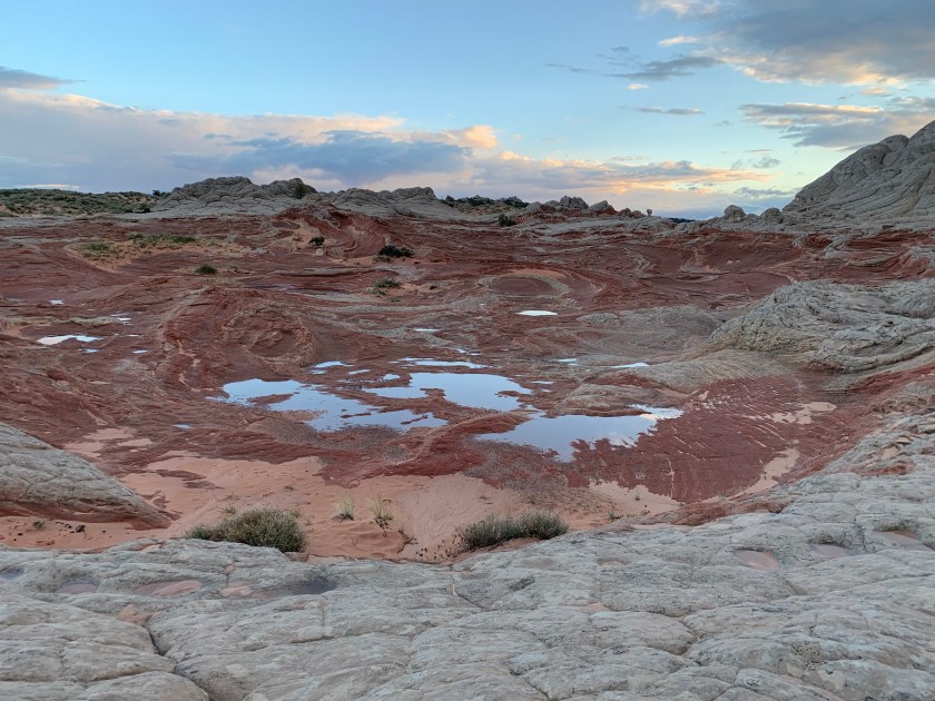


 Dempster Highway – the orange flags mean road damage — they really don’t mark all the road damage…